Wednesday 28 December 2022

Free Muni for New Year’s Eve

Free Muni for New Year’s Eve
By Stephen Chun

White text "Leave the driving to us with additional advisory subtitles" on a red canvas background with city skyline silhouette.

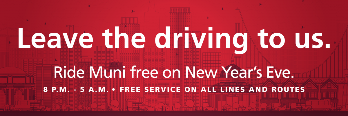
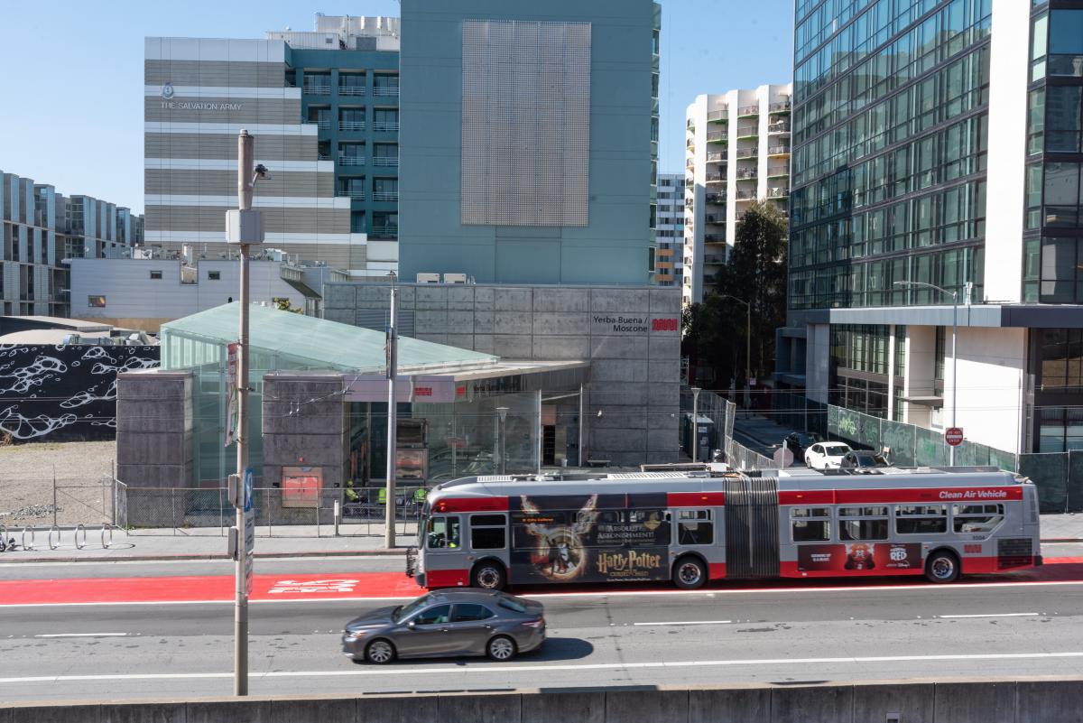
For the 23rd consecutive year, the San Francisco Municipal Transportation Agency (SFMTA) will offer free rides on New Year’s Eve from 8 p.m. on Saturday, December 31 through 5 a.m. on Sunday, January 1. Extra Muni Metro Subway Service will be provided from 8 p.m. Saturday to 2:15 a.m. Sunday. Extra Owl Service will be provided from 10 p.m. Saturday to 5 a.m. Sunday

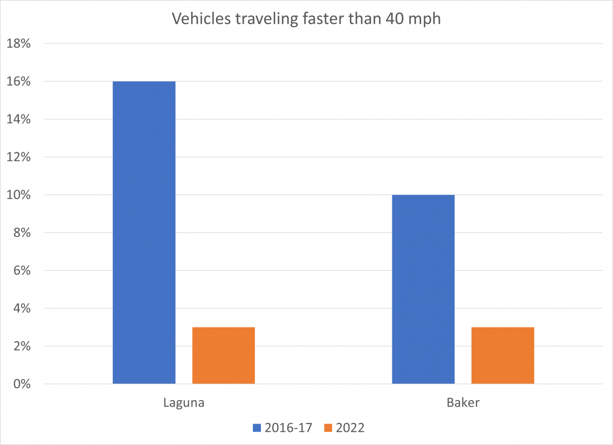
This program supports San Francisco’s Vision Zero goal to eliminate traffic fatalities.

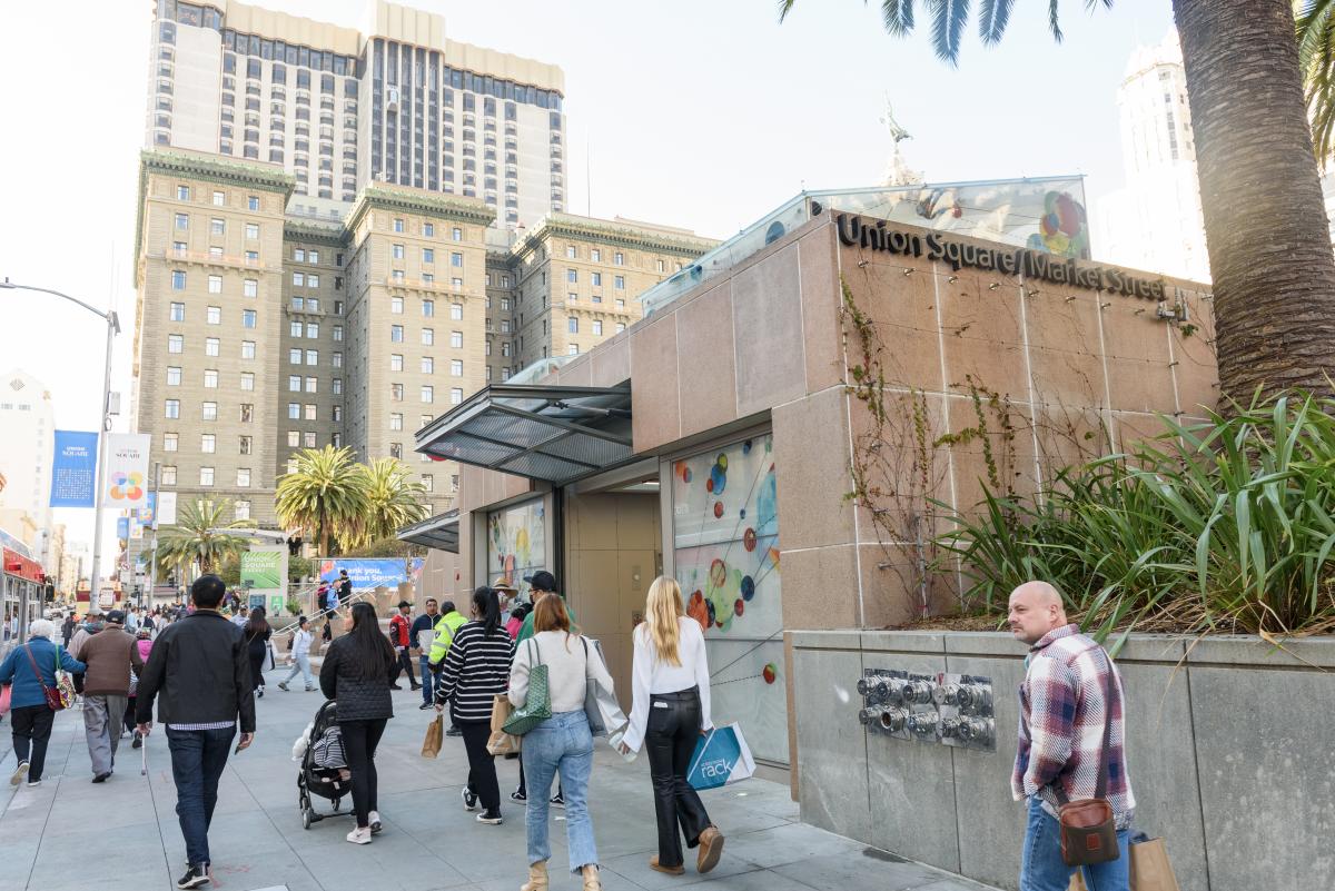
Ride Muni Free New Year’s Eve includes all Muni lines and routes. Clipper Card customers should NOT tap their cards to make sure they don’t get charged a fare. Muni Mobile passes will not be necessary. Metro fare gates will be open that night. All information, including schedules and stops, will be posted on New Year's Eve Free Muni and Extra Service or SFMTA.com/NYE. Clipper Card customers should NOT tap their cards to make sure they don’t get charged a fare.

Don’t drink and drive, let Muni do the driving.

New Year's Eve Muni Service

  • Complimentary Muni service from 8 p.m. Saturday, December 31 to 5 a.m. Sunday, January 1.
  • Please do not tag your Clipper® card. If you tag it, you will be charged.
  • Please do not activate a MuniMobile ticket. Metro fare gates will be open.
  • Extra Muni Metro service:
    • Trains between West Portal Station and 4th & King from 8 p.m. to 2:15 a.m.
    • Additional trains between West Portal and Embarcadero Station from 8 p.m. to 2:15 a.m.
    • Transfer at West Portal Station to OWL bus lines.
  • Extra service on the OWL Network, from 10 p.m. to 5 a.m.:

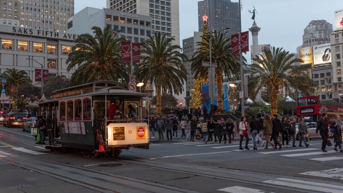
At midnight on New Year’s Eve, a city-sponsored fireworks show from a barge off The Embarcadero, south of the Ferry Building, will take place. Motorists should anticipate delays in the area from approximately 11 p.m. to 1 a.m. and pedestrians are advised to use caution when traveling.

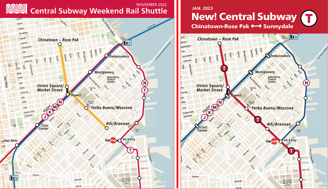
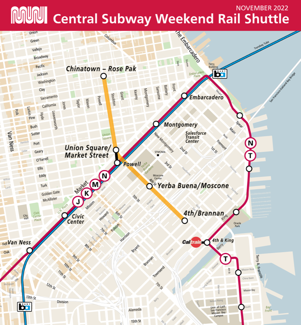
Note: Central Subway will provide free rail shuttle service from Chinatown Rose-Pak to 4th / Brannan St on Saturday, December 31st and Sunday, January 1st from 8 am to 5 pm, instead of midnight. We encourage those planning to use the Central Subway after 5 p.m. this weekend to use the 30 Stockton and 45 Union/Stockton which are scheduled to come every 15-20 minutes. For further information on our staffing & service plans, please visit Central Subway Will Close Early On The Holiday Weekends.

Regional Transit Connections for New Year's Eve

  • BART will provide additional service on January 1.
    • Full fare pricing will be in effect.
    • The last East Bay bound train running through Downtown San Francisco will be at around 1:30am and the last Southbound train heading toward Millbrae will run through Downtown San Francisco at 2:10am.
    • For more details & trip times, please visit BART’s New Year’s Eve service article.
  • Caltrain service will be running on a Weekend Schedule. For more details, please visit https://www.caltrain.com
  • SamTrans service will be from 8 p.m. on December 31 until 3:30 am on January 1. For more details, please visit http://www.samtrans.com 


Published December 28, 2022 at 12:33PM
https://ift.tt/9YNlvLk

Monday 19 December 2022

Upcoming Capacity Indicators

Upcoming Capacity Indicators
By Christopher Ward

Image of new stick figures indicating bus capacity on shelter signs.

Next Generation Customer Information displays will show capacity indicators: One figure means there are many seats available. Two figures indicates that there are likely a few empty seats available. Three figures tell you that there’s likely only standing room available.

The SFMTA continues expanding trip planning and accessibility features and improving Muni predictions. This is part of the ongoing Next Generation Customer Information System (CIS) project. One of the newest features is a capacity indicator.

A capacity indicator helps customers understand how much space is available on vehicles. Customers can see the indicator on our Next Generation displays in the bus shelters and on train platforms. Customers may use this information to make travel choices. For example, customers can choose to wait for a less full vehicle or take an alternative route.

As of November 2022, Muni vehicles equipped with automatic onboard passenger counters send capacity information to our Next Generation CIS. This information is now shown symbolically with stick figures. One figure means there are many seats available. Two figures indicates that there are likely a few empty seats available. Three figures tell you that there’s likely only standing room available.

Customers should always yield the priority seating area for people with disabilities, older adults, and pregnant persons.

We’re excited to finally bring these features to our customers and build a system that will help make Muni travel even more efficient, reliable and enjoyable.


Published December 19, 2022 at 03:08PM
https://ift.tt/Gwp7MsH

Thursday 15 December 2022

A Brief History of the T Third Part 2: 1980s-2023

A Brief History of the T Third Part 2: 1980s-2023
By Jeremy Menzies

Beginning in January 2023 full service on the new T Third extension 2023 will run from Sunnydale to Chinatown every day. In this two-part blog series, we will look back at some of the history of the T Third Street line. Part 1, published last month goes through the first 100+ years. In Part 2, we look at the recent history of the T Third and Central Subway projects from the 1980s to today. 

The Call for Better Transit: 1980s-90s 

In the decades following World War II, the neighborhoods along the southern end of 3rd Street became more economically depressed and transit service declined.  Residents felt cut off from the rest of the city as bus service did not meet their needs. 

Passengers lining up to board a bus on a busy city street with buildings in the background 
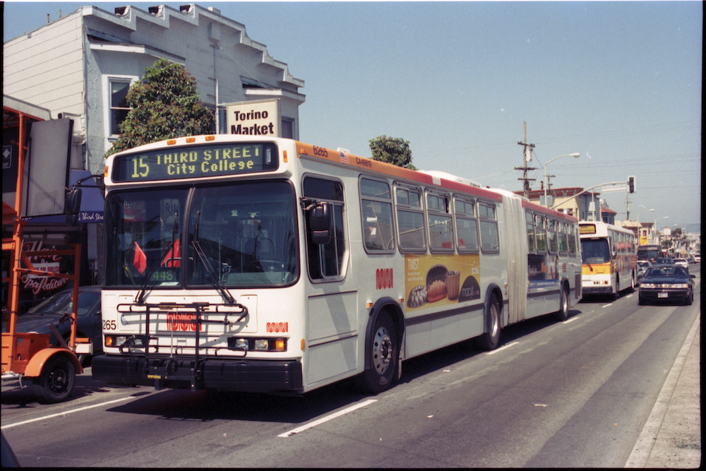
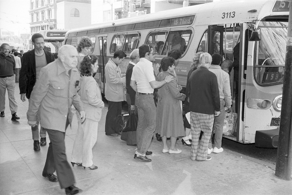
People boarding a 15 Route bus on 3rd Street near Market in 1983. Bus service on the 15 provided critical north-south service through the City’s busiest areas. 

In the late 1980s, the city was looking to revitalize the Mission Bay, Dogpatch, and Bayview and reliable transit was critical to this goal. Early outreach and research resulted in the 1993 Bayshore Transit Study. This initial plan solicited community input on several possible solutions on how to improve transit to these neighborhoods. Two years later in 1995, the Four Corridor Plan built upon the Bayshore Transit Study and elevated 3rd street as the top priority for San Francisco’s long-range transit plan. It was clear that residents, particularly in Bayview, wanted rail service to return to 3rd Street. 

T Third Phase 1: 1990s-2007 

These reports and outreach formed the backbone of the Third Street Light Rail Project, which would be built in two initial Phases. Phase 1 involved extending Muni Metro service from 4th and King to Bayshore Boulevard along 3rd Street. Phase 2 would focus on the 4th and Stockton corridors to extend the service into Chinatown and possibly North Beach. 

By the end of the ‘90s, funding was coming in to make Phase 1 a reality. Early plans for the T also included a new rail maintenance facility, Muni Metro East, as well as a turnback loop in Mission Bay and a direct connection to the Bayshore Caltrain Station. Due to various factors during preconstruction planning, the Mission Bay Loop and Bayshore Caltrain connection were dropped from the T Line plan. 

People in business attire and hard hats smiling with shovels in hand over a large pile of dirt under s station structure

A groundbreaking ceremony for T Third construction was held on May 28, 2002 at the 4th and King Caltrain Station.  

Construction of 5.1 miles of new tracks, overhead power lines, lighting, stations, and a variety of other improvements took five years to complete. On January 13, 2007, free weekend shuttle service commenced on the new line and full weekday service started on April 7. Just one year later in 2008, the Muni Metro East rail yard opened, boosting Muni’s ability to serve the new line. For the first time in 50 years, rail service returned to the eastern waterfront. 

A long perspective view of a corridor showing the city's neighborhood skyline 
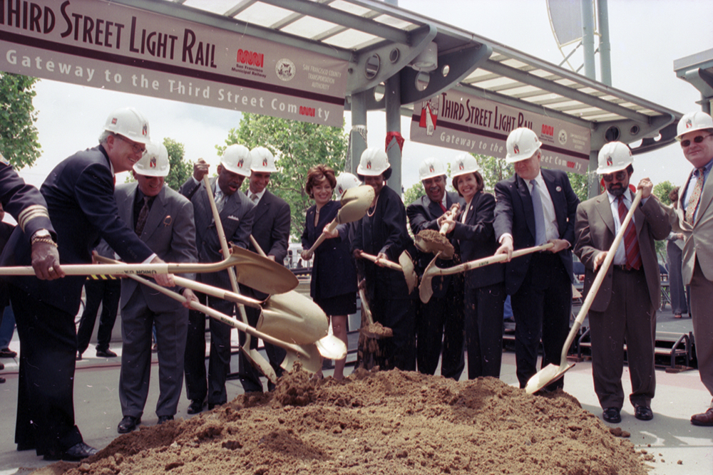
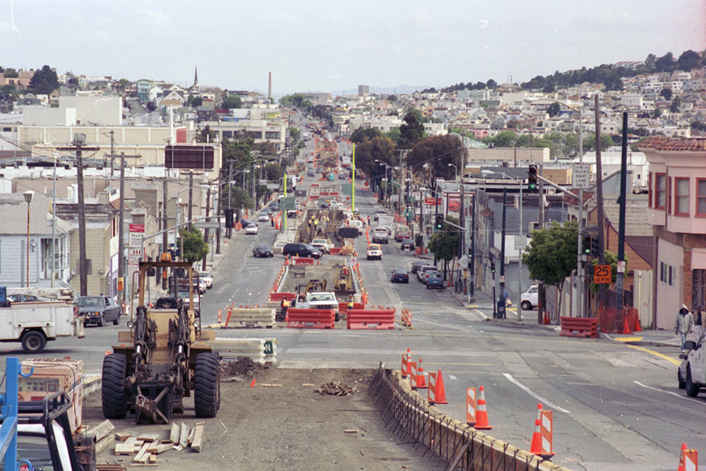
View north along 3rd Street at Jamestown Avenue during construction in 2004. 

T Third Phase 2: Central Subway 

Planning and outreach for Phase 2 of the T Line had already begun when the line opened in 2007. The Central Subway Project was created to address the transit needs of Chinatown, Union Square and South of Market. Construction would extend the T nearly two miles and build the first new subway in the city since the 1970s.

Construction and crew underground in a front of two boring entrances 
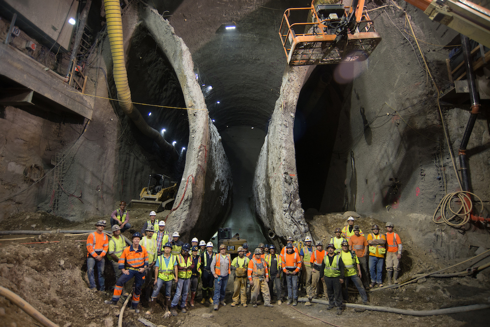
This 2016 photo, taken inside the excavation for Chinatown Station shows the massive scale of the Central Subway Project. 

Early proposals showed the Central Subway traveling north on 3rd Street and along Geary where it would turn up Stockton to end in Chinatown. Going south, the line would branch and exit the tunnel on 4th Street. The challenges of construction along 3rd and at Market Street resulted in a plan to run the line on 4th and Stockton streets. It was also decided to tunnel underneath the Market Street Subway/BART tunnels using special tunnel boring machines instead of more conventional construction methods. 

The official groundbreaking ceremony took place on February 9, 2010. The arduous process of building a subway with four stations through San Francisco’s densest neighborhoods began soon after. Despite an intensive construction period with project delays and cost increases, the Central Subway opened for service on November 19, 2022.  

Passengers boarding onto a train in a station on a busy platform
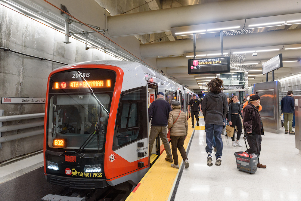
Opening day of the Central Subway on November 19, 2022. Thousands of people came out to see and ride in the long-awaited subway. 

Over 30 years in the making, the T Third line follows in the footsteps of the first horsecars that ran over 160 years ago. However, this is not the end of the line for the T. Planning is already underway on the T Third Phase 3 extension. Aimed at expanding service beyond 3rd Street, this extension will mark yet another chapter in San Francisco’s transportation history. 


Published December 15, 2022 at 11:22AM
https://ift.tt/SZzMbnr

Wednesday 14 December 2022

Central Subway Brings More Art to Union Square

Central Subway Brings More Art to Union Square
By Enrique Aguilar

Street view of a station entrance and downtown buildings with dozens of pedestrians holding various items

Main entrance to Union Square/Market Street Station during special weekend service 

The Union Square/Market Street Station is centered in the heart of the Union Square neighborhood, known for world-class shopping and notable art galleries. With the opening of the Central Subway, a new public art collection arrived, with color schemes complementing the station’s modern architectural design. Collaborations between artists reign at this station, allowing a blend of different artistic concepts. 

  • Erwin Redl titled his piece Lucy in the Sky. It is an illuminated installation comprised of hundreds of translucent 10 x 10 inch light panels, each containing an array of color LEDs. A diamond-shaped pattern is formed by suspended light panels along the entire length of the concourse level corridor’s ceiling. They are computer programmed to slowly change color and display simple patterns, creating an immersive and kaleidoscopic experience.  

  • Jim Campbell and Werner Klotz created a site-specific stainless-steel sculpture called Silent Stream, located on the station’s platform level. Comprised of highly polished steel disks, the overhead installation loops its way through the struts along the length of the platform and reflects the passengers and trains passing below.  

  • Amanda Hughen and Jennifer Starkweather integrated a design into the glass deck and the front faces of the glass elevator enclosures. Titled Convergence: Commute Patterns, the artwork is based on the dynamic and diverse pathways, commute patterns and arterial structures above and below the streets of the Bay Area. The artwork’s visual impact on the station’s exterior alternates from being subtle during the day to backlit at night.  

Watch an interview video with comments from Amanda Hughen, Jennifer Starkweather, Erwin Redel, Jim Campbell and Werner Klotz. Get to know the artists and learn directly from them about their work at the new Union Square/Market Street Station. A special thank you to the San Francisco Arts Commission for making public art possible at the four new stations. 

Special Weekend Service started on Nov. 19 and will last through the end of the year, Saturdays and Sundays from 8 a.m. to midnight. Full revenue service will begin January 7, Monday through Friday, 6 a.m. to midnight and Saturdays and Sundays, 8 a.m. to midnight. 

For more artist information: 


Published December 14, 2022 at 04:24PM
https://ift.tt/1HpkW8y

Tuesday 13 December 2022

New T Third Route in Central Subway Starting January 7

New T Third Route in Central Subway Starting January 7
By Mariana Maguire

Map showing the new alignment of the T Third to Chinatown-Rose Pak Station, connecting from 4th and King streets and continuing north to Central Subway; existing Muni Metro system's J Church, K Ingleside and M Ocean terminating at Embarcadero Station; the N Judah continuing along the Embarcadero to Caltrain at 4th and King streets.

New T Third service via Central Subway starts January 7 with service between Sunnydale and Chinatown-Rose Pak Station.

On Saturday, January 7, the T Third starts its historic new route, providing a direct Metro connection between Sunnydale and Chinatown-Rose Pak Station. Service runs Mondays through Fridays, 6 a.m. to midnight. every 10 minutes and Saturdays and Sundays, 8 a.m. to midnight every 12 minutes. The new T Third line vastly improves transportation to and from some of San Francisco’s most densely populated areas and major shopping corridors, expanding transit options and new connections.

The new T Third route will travel north to the new Central Subway from 4th & King platform. It will no longer turn onto King Street or run along the Embarcadero and the Market Street subway. Also, the K Ingleside will now travel between Balboa Park and Embarcadero Station.

New Connections

Customers traveling to stops along the Embarcadero, the baseball stadium at 2nd and King streets should transfer to the N Judah. Customers should transfer at Powell Station to Union Square/Market Street Station for the T Third going to Sunnydale.

To transfer to the new T Third at Union Square/Market Street Station from the J Church, K Ingleside, M Ocean View, N Judah or BART at Powell Station, you can connect entirely underground. From the Powell Station platforms, take the elevator or follow signs to concourse level, then follow signs to Union Square/Market Street Station.  

Customers on the T Third connecting to other Muni Metro routes or BART should follow signs on the Union Square/Market Street Station platform toward Stockton/Ellis streets.

Navigating the Union Square/Market Street Station

The new Central Subway stations have many new features, including long escalators – the longest in the United States west of the Mississippi – and two glass elevators at every level for more accessibility.

Customers who need to use the elevators to the platform should bypass the fare gates near the street entrances at Union Square/Market Street Station. Instead, use the fare gates in the center of the concourse.

MuniMobile and Lifeline customers may use any fare gate at the Union Square/Market Street Station.

Special Chase Center Event Service

During events at Chase Center, the SFMTA will run special event service about every 10 minutes in addition to normal T Third service. The additional special event trains – with “S Chase Center” head signs – will serve all stops between Chinatown-Rose Pak Station and UCSF/Chase Center. From end to end the ride takes only 20 minutes. Best of all, your event ticket is your Muni fare. No additional Muni fare needed!

Customers traveling past Chase Center during this special event service should check train head signs and only board “T Third” trains for a one-seat ride to their destination.

We know new T Third service in the new Central Subway is a big change that will take time to get used to. We’re here to help! Stay tuned for helpful wayfinding guidance and orientations, and check out our Frequently Asked Questions for helpful commuting tips.

Send us your questions at TellMuni@SFMTA.com so we can help you navigate better and become a Muni Metro pro!


Published December 13, 2022 at 12:29PM
https://ift.tt/KVWzuQx

Friday 9 December 2022

Public Artwork Unveiled Inside New Station in Yerba Buena

Public Artwork Unveiled Inside New Station in Yerba Buena
By Enrique Aguilar

Have you had a chance to explore the Central Subway's new stations? Special weekend service is Saturdays and Sundays, from 8 a.m. to 12 a.m. midnight, through the end of the year. Ride the trains and be mesmerized by beautiful artwork at each new station. 

Muni customers will encounter public art when using the four new Central Subway stations to reach their destinations. The art was commissioned by the San Francisco Arts Commission and funded by the City’s Art Enrichment Ordinance, which allocates 2% of the total eligible costs of public works projects for public art. Public art helps draw out the identity of a space, aids in understanding a neighborhood's historical or cultural significance, and builds a connection between the visitor and surrounding community. 

The Yerba Buena/Moscone Station includes artwork by Catherine Wagner, Leslie Shows and Roxy Paine. The installations can be found on the station's surface and concourse levels. 

  • Catherine Wagner transformed photographs she took in the late 1970s that document the monumental construction of the George Moscone Convention Center, and focus on ideas of transformation. Titled Arc Cycle, the artwork reproduces several iconic images from this photographic series, translating them into laser-etched granite at the concourse level, and art glass at the station’s entry.  

  • Leslie Shows created Face C/Z, installed in the ticketing hall on the concourse level. Based on an image of iron pyrite made with a consumer grade scanner, the artwork was hand fabricated in a unique style combining mirrored, fused, painted, and engraved glass, sheet metal, and other permanent materials The pyrite (or "fool's gold") image speaks to ever-shifting notions of value in industry and aesthetics, the many historical "gold rushes" of California, and the idea that anything might be made valuable under the right circumstances.  

  • Roxy Paine created a monumental, 110 feet tall sculpture for the public plaza at 4th and Clementina streets outside of the station. Titled Node, the artwork is conceived to emerge from the complex manmade structures existing beneath the sidewalk, including the subway, communication networks, electrical and water supply, and waste systems that are all lifelines of a functioning city. According to Paine, the sculpture is "an elegant line connecting earth to sky, people to underground systems, and sculpture to city." Node is expected to be installed in early 2023. 

Rendered image of an art node piece in front of a building with a person in the foreground

Mockup of art installation on the station's plaza

Watch an interview video with artists Leslie Shows and Catherine Wagner to learn more about their inspiration for their work on display at the new Yerba Buena/Moscone station. A special thank you to the San Francisco Arts Commission for making public art possible at the four new stations. 

Full revenue service will begin January 7, Monday through Friday, 6 a.m. to midnight and Saturdays and Sundays, 8 a.m. to midnight. 

Stay tuned for additional blogs showcasing public art at the other new Central Subway stations. 

For more artist information:


Published December 09, 2022 at 03:35PM
https://ift.tt/SnQGkNW

Hop Onboard Muni and Enjoy Downtown Union Square

Hop Onboard Muni and Enjoy Downtown Union Square
By Pamela Johnson

A filled Cable Car at a busy intersection in Downtown San Francisco decorated in holiday festivities with dozens of shoppers and vehicles

The iconic Cable Cars are just one of the many options to get you to all the holiday festivities in Downtown Union Square!

The SFMTA would like to wish you a Happy Holidays! With festivities, dining, shopping and all the many holiday activities to choose from, Downtown Union Square, much like the rest of the city is making optimistic strides in the city’s economic recovery. Catching Muni, paratransit or a taxi to downtown supports small businesses and is a big boost to our transit goals. Below is a comprehensive list of transit and parking options to head into the heart of the downtown shopping and festivities this holiday season.  

Central Subway Special Weekend Shuttle 

Muni Metro Light Rail  

Muni Bus Lines 

Cable Cars 

  • Invented here nearly 150 years ago and named a National Historic Landmark in 1964, hop on any of our beloved world famous Cable Cars this season. Be sure to lookout for several Cable Cars decorated in the spirit of the holidays by our dedicated and talented staff. Passengers will travel up and down the hills of San Francisco in this annual holiday tradition.  

Additional Services  

  • Free One-Hour Parking at Union Square Garage - the Mayor will be providing one-hour of free parking at our Union Square garage through the end of the year, regular posted rates apply thereafter. All facilities have increased staffing and security, restriped its parking spaces, and upgraded much of its overhead lighting, to make parking easier and safer this holiday.   

  • Additional SFMTA parking garages - Ellis O’Farrell, Sutter-Stockton and Fifth & Mission / Yerba Buena 

  • If you drive, parking in a city-owned garage may be the way to go. And parking rates at city-owned garages are typically 40% less expensive than parking prices in privately-owned garages.  

  • Taxi - with knowledgeable and trustworthy drivers, save some gas and catch a taxi. You’ll not only ride in a clean and safe vehicle, your taxi can use our red transit-only lanes to get to your destination quicker. And since November 9, the Taxi Upfront Fare Pilot Program has been helping customers book a taxi trip through a taxi e-hail app and pay a flat-rate, upfront fare.  Being able to request a taxi through approved third-party apps provided customers with upfront information about their fares, relieve meter anxiety and allow customers to price shop for similar on-demand services.

  • Essential Trip Card - older adults, people with disabilities and other eligible participants can benefit from this discount program paying 20% of the cost of a regular cab. Don’t forget our Shop-a-Round program, a convenient, low-cost shuttle that makes it easier to go grocery shopping for all your holiday meals. The shuttle takes groups of riders to grocery stores or supermarkets in San Francisco where they want to shop. The service offers registered older adults and people with disabilities personalized assistance that is not available on Muni bus and rail lines. 

  • SF Paratransit - is a van and taxi program for people unable to independently use or access public transit because of a disability or disabling health condition. Participants may also use their Essential Trip Card for this service.  

For real-time updates, follow us on https://twitter.com/sfmta_muni or visit SFMTA.com/EmailText to sign up for real-time text messages or email alerts. 

For details of Muni re-routes, visit SFMTA.com/Updates. This website will be updated when it is closer to the event date. 

For additional notifications and agency updates, subscribe to our blogs, daily or weekly updates. 


Published December 09, 2022 at 10:20AM
https://ift.tt/dDzhng9

Thursday 8 December 2022

Riders are Feeling the Difference on Geary

Riders are Feeling the Difference on Geary
By

Image of 38 Geary bus and new improved crosswalks on Geary Boulevard

The results are in: the Geary Rapid Project has delivered a faster, more reliable bus trip and a safer street, according to the SFMTA’s recently published evaluation report for the project.  

A faster, more reliable bus ride 

One out of every ten passengers stepping onto a Muni vehicle will ride on Geary Blvd., which makes reducing travel time on the corridor a key piece of improving transit in the city. The transit lanes installed as part of the Geary Rapid Project protect buses from traffic congestion, while smarter traffic signals allow buses to get green lights more often. Similar transit upgrades have been made across the city as part of the Muni Forward program, making your next San Francisco destination closer than ever. 

Transit travel time improved after the quick-build phase of the Geary Rapid Project in late 2018 and early 2019, and again after the full project was completed in 2021 — with savings as great as 18%. Westbound travel times generally improved the most — up to 3.6 minutes during the PM peak — providing a daily 38R Geary Rapid rider 18 hours of savings per year. Although the biggest time savings were seen during commute hours, with 36,000 riders traveling on Geary around the clock each day, even smaller gains outside of peak hours adds up to major travel time savings for all Geary riders combined.  Travel time reliability also improved up to 37%, which means that the time spent waiting for the next bus is more consistent. 

A safer street  

Reducing Muni-involved collisions is critical to protect our passengers and operators. It also keeps Muni service running smoothly; even non-injury collisions cause buses to be taken out of service. Adding dedicated transit lanes on Geary Boulevard has substantially reduced the rate of Muni-involved collisions on the corridor. The collision rate of 38/38R buses decreased by two-thirds and is now about half that of the current citywide Muni bus collision rate. Several years of data will be necessary to fully evaluate the project’s impacts on reducing traffic collisions in general. But one promising indicator is that there was a 70-80% reduction in vehicles traveling over 40 mph (more than 5 mph over the speed limit). A suite of improvements to calm the “expressway” section of the corridor, including a reduction in general-purpose travel lanes to two per direction, new crosswalks, narrower travel lanes and bulb-outs (sidewalk extensions) were implemented to encourage people driving to slow down. 

Graph comparing the share of vehicles traveling faster than 40mph before and after the Geary Rapid Project was implemented. At Laguna Street, speeding rates dropped from about 16% to 3% of vehicles. At Baker Street, speeding rates dropped from about 10% to 3% of vehicles. Before counts were taken in 2016-2017. After counts were taken in 2022.

Comparison graph of 40 mph travel speeds before and after the Geary Rapid Project. 


Keeping transit lanes clear 

One of the final portions of the project was painting the transit lanes red. This “red carpet” treatment makes it easier for drivers to know where they’re allowed to drive. When we make transit lanes extra clear with red paint, drivers are less likely to get a citation for unintentionally driving in a transit lane. Previous SFMTA studies showed that the number of private vehicles illegally using transit lanes declines about 50% when the lanes are painted red. Sure enough, the number of vehicles entering the lanes on Geary dropped by 47% from 2019 to 2022, even as traffic congestion returned after COVID restrictions eased (vehicles driving legally in the transit lane to turn right or access curbside parking or driveways were not included). 

The full evaluation report is available on the SFMTA website and covers several additional metrics, including street space allocation, Muni customer experience and parking availability. 

The success of the Geary Rapid Project has informed the final design for the second phase of upgrades, the Geary Boulevard Improvement Project, which proposes to expand these improvements west into the Richmond District.  

A photo is worth a thousand words to show the improvements made on Geary Boulevard. These birds-eye shots provide representative examples of the street design on Geary before (August 2018) and after implementation (February 2022) of the Geary Rapid Project.


Published December 08, 2022 at 02:02PM
https://ift.tt/MbdDK28

Shared Spaces are Here to Stay. Permit Renewals are Due January 15, 2023.

Shared Spaces are Here to Stay. Permit Renewals are Due January 15, 2023.
By Anne Yalon

A family shown sitting in a colorful outdoor dining booth.

Shared Spaces, amongst many other benefits, allows our residents and families to enjoy safe and social outdoor dining. Seen here are the the owners of Tio Chilo’s Grill and their children in the restaurant’s parklet on 24th Street in the Mission. 

San Francisco’s popular Shared Spaces program allows merchants, restaurants and arts and culture organizations to use the curbside, sidewalk and other public spaces to conduct local business activities and stay afloat. What emerged as an economic lifeline during the pandemic is making San Francisco’s streets more energized, engaged and activated.

Many of the Shared Spaces parklets have become central gathering places for the local community. Our parklet makes me feel like when I go to Mexico, where outdoor seating is everywhere. People end up joining their friends in our parklet. It is a space for our customers and our community," said Liz Vazquez, owner of Tio Chilos Grill. Ray Bair, owner of Cheese Plus, said, "My Shared Space has been a community gathering space. It's an ideal location because we are on a corner. I go out to it every afternoon and see so many people from the neighborhood sitting and enjoying the space. It's so satisfying to see people using the space for what the Shared Spaces program was intended for."

Now, Shared Spaces is transitioning from an emergency initiative to a permanent program. In July 2021, the San Francisco Board of Supervisors unanimously passed legislation introduced by Mayor London Breed to make the Shared Spaces Program permanent. Permits from the pandemic-era Shared Spaces Program were extended to June 30, 2022 and then later to March 31, 2023. Parklet owners have until January 15, 2023 to renew their permits which, once approved, will go into effect on April 1, 2023.

The extension has allowed additional time for small businesses to make any necessary modifications to their shared spaces as they transition into a longer-term permit. Because many of the Shared Spaces were built very quickly, some of them need to be modified to meet the most up-to-date guidelines for safety and accessibility.

So far, 450 permit applications have been submitted for the long-term Shared Spaces program. San Francisco operators who want to keep their existing outdoor Shared Space beyond March 2023 need to renew their permits by January15, 2023. Permit holders wishing to end their existing Shared Space also need to notify Shared Spaces.

Parklet owners who are still deciding if a Shared Spaces permit will work for their business or need to modify their Shared Space to fit the city’s design guidelines can watch the 2-minute design guidelines videos. These videos explain how to make Shared Space safe and accessible for all. They focus on intersection safety and visibility, and emergency access for the fire department. Another video about disability access is in the works.

More information for parklet owners is available at these upcoming events:

Application and site plan workshop

When: Tuesday, Dec. 13, 2 p.m.-3:30 p.m

Where: The Crossing, 200 Folsom St. San Francisco. Register here.   

Who: Current parklet operators wishing to apply for a permit.

This interactive, in-person training will ensure that parklet operators and professionals designing and building parklets understand how to create a site plan and an application. Have a question? Bring your application and site plan with you and have our team of experts review it and provide feedback.  Please RSVP and submit your questions in advance here. The training will be 1 hour and 30 minutes in length, including a 45-minute Q & A.   

Parklet Design Training 

When: Thursday, Dec. 15, 9:30 a.m-11 a.m.  

Where: 49 South Van Ness, Room 136.egister here  
Who: Designers, builders and contractors of parklets.
This interactive, in-person training will ensure that professionals designing and building parklets understand design requirements and best practices for safety and accessibility at Shared Spaces parklets. Attendees will receive a certificate of attendance and will be listed on the program website as having attended the City’s training. Please RSVP and submit your questions in advance here. The training will be 1 hour and 30 minutes in length, including a 30-minute Q & A.  

Roadway Closure application and site plan workshop

When: January (check the Shared Spaces website for updates)

More information is available on the Shared Spaces website. To see photos of parklets and featured parklet owners, check out Shared Spaces on Instagram and Twitter.

The SFMTA is proud to help operate the program in partnership with the Mayor’s Office, Department of Planning, Department of Public Works, Digital Services, Entertainment Commission, Office of Economic and Workforce Development, Mayor’s Office on Disability, 311, Department of Technology, Public Utilities Commission and Fire Department.


Published December 08, 2022 at 12:06PM
https://ift.tt/6KdYpsI

Wednesday 7 December 2022

Slow Streets are Here to Stay—Here's How to Use Them

Slow Streets are Here to Stay—Here's How to Use Them
By Eillie Anzilotti

.Children, parents and a bicyclist seen crossing in the crosswalk with a police officer guiding traffic

Slow Streets provide safe travel for children, families, wheel users, older adults, persons with disabilities and the entire community

The success of Slow Streets depends on everyone working together to keep these spaces safe and joyful. 

On Tuesday, December 6 the SFMTA Board of Directors approved an ongoing, post-pandemic Slow Streets program for San Francisco. That means that Slow Streets are here to stay!  

We recognize that there are a lot of questions about how to use Slow Streets. To answer them, we created a fact sheet in English, Spanish, Chinese, Russian, and Filipino. You can find that fact sheet linked here

The main thing to remember is: Everybody is welcome, and please go slow! 

Slow Streets create safe corridors for people who prefer not to drive, while preserving parallel arterial streets for vehicles. On Slow Streets, kids can walk and bike themselves safely to school, families can run errands together by bike, and people with disabilities can find safe spaces to navigate their communities.  

Whether you are walking, rolling, riding a bicycle, or driving, please watch out for and be kind to your fellow Slow Street users. These streets are community spaces, and basic decency and consideration will go a long way. 

In general, we ask that communities make sure Slow Streets can still function as active roadways. That means keeping decorations out of travel lanes, and not adding any hard-to-move items, like furniture, to the streets. If you want to host an event that requires the full use of a street, the Slow Streets and the SFMTA Special Events teams are happy to help. Our program team is always available to discuss and respond to any of your questions. 

Since Slow Streets were first introduced at the beginning of the COVID-19 pandemic, they have created safe, shared community spaces on residential streets across San Francisco. Slow Streets are an essential part of how San Francisco will meet its Vision Zero and Climate Action goals. SFMTA data shows a drop in collisions on Slow Streets, which means they’re safer for all users. And having safer streets means more people are encouraged to bike, walk, and roll to get around.  

The program will be able to expand to meet community needs and contribute to a growing network of streets that are safe and welcoming to people of all ages and abilities. While the Board initially approved 16 corridors for inclusion, more will be added in the future. 

We look forward to expanding the program and offering more ways for communities to activate their Slow Streets. Keep an eye out for news and opportunities by subscribing for updates at SFMTA.com/SlowStreets


Published December 07, 2022 at 12:09PM
https://ift.tt/BpbtiV1

Wednesday 30 November 2022

A Brief History of the T Third Part 1: 1860-2007

A Brief History of the T Third Part 1: 1860-2007
By Jeremy Menzies

Earlier this month, we launched free weekend shuttle service in the Central Subway. And come January 7th, our 4 new stations will connect directly to the rest of the T line from Sunnydale to Chinatown. Through this two-part blog series, we will look back at some of the history of the T from the 1860s to today!

In Part One, we’ll look over the first 150 years from the 1860s to the 2000s. Next month in Part Two, we will take a closer look at the history of the T and Central Subway projects leading up to today’s service. 

The Horsecar Era: 1860s-1890s 

Starting in the 1860s, transit service along today’s T Line was provided by horsecars. These were small rail cars (that looked much like a cable car) that were pulled along tracks by horses. Two companies, the Omnibus Railroad and the North Beach & Mission Railway, operated horsecar lines on parts of the path of today’s T. These lines were mainly meant to connect North Beach with the 3rd and 4th street corridors as far south as about Townsend Street. 

Image of a busy intersection from the 1890's with horse drawn streetcars, pedestrians and a department building are seen

This photo circa the 1880s shows the busy intersection of Kearny, Geary, 3rd and Market streets, looking south to 3rd.  In the foreground is a horsecar running up Kearny from 3rd. 

Further south on 3rd (then called Kentucky Street), horsecars were operated by the Potrero & Bay View Railroad. Here the route ran over two bridges across Mission Bay and Islais Creek (known as “Longbridge”), ending near today’s 3rd & Gilman. This route served the industrial heart of San Francisco and opened up development in the Bayview but was not very profitable because of its length. 

The Electric Streetcar Era: 1890s-1940s 

The 1890s marked the dawn of the electric streetcar era in San Francisco. A new technology, electric-powered cars could carry more people over longer distances faster than both horse and cable cars. On top of that, they were cheaper to operate and increased profit potential for transit companies. 

Two streetcars from 1911 shown with a person seen in the middle as well as a horse drawn carriage on the side

This 1911 photo shows two cars passing at 3rd (Kentucky) and 20th streets. On the left is a 16 Line car running to its terminal in the Bayview. At right is a 30 Line car heading north to 8th and Market. 

In 1894, the first electric streetcar line began operating along parts of today’s T Line. Known as the 3rd & Kearny Line, it followed much the same route as the early horsecars from North Beach to the Southern Pacific Railroad Depot on Townsend Street. It was extended into the Bayview to 3rd and Palou and eventually was reformed into the 15, 16, and 29 Lines. Each of these served a different portion of the corridor covering differing needs of riders travelling through downtown or all the way out to the Bayview. 

An old streetcar seen on the mainline with a few parked vehicles along the sidewalk and sundry stores in the background

A Muni F Stockton streetcar passes Vallejo Street in this photo from 1916. 

Muni’s first streetcar line to serve a similar route to the Central Subway portion of the T was the F Stockton, which opened for the 1915 Panama Pacific Exposition. The F Line ran along 4th and Stockton streets to serve South of Market, Union Square, Chinatown and North Beach before heading out to end at Chestnut and Scott streets. 

Buses along the Bay: 1950s-2000s 

Following World War II, the 3rd Street corridor was among the many that saw transit service shift from streetcars to buses. By 1951, the 15 Kearny route served much of the area once covered by the 15, 16, and 29 streetcar lines.  

Cars and buses seen traveling during the busy commute on a congested street.

Buses on the 30, 15 and 42 fight the morning rush northbound on 3rd Street in this 1959 photo. 

Traveling along portions of today’s 8 Bayshore and T Third, the 15 route went from Powell and Jefferson streets all the way to Geneva and Mission. Eventually, it was extended to City College on Ocean Avenue. While not the only route to serve the area, the 15 carried the bulk of the load for people wishing to travel along this corridor. 

On Stockton Street, the 30 Stockton bus took over for the F, following the same route through Chinatown, Union Square, and South of Market to 4th and Townsend streets. 

An articulated bus and coach seen traveling on a busy street

Many long-time riders will recognize this view of a 15 bus on 3rd & Palou. Discontinued with the opening of the T Line in 2007, the 15 was revived as the 15 Bayview-Hunter’s Point Express in 2021.  

Tune in next month for a closer look at the history of the T Third and Central Subway Projects. 


Published November 30, 2022 at 04:08PM
https://ift.tt/FiMCBzu

Monday 28 November 2022

Construction Starts on the Battery/Sansome Quick-Build

Construction Starts on the Battery/Sansome Quick-Build
By Eillie Anzilotti

Rendered image of the completed Battery/Sansome Quick Build Project" 

Rendered image of the completed Battery/Sansome Quick Build Project

The first-ever protected bike lane in the Financial District is on its way in! 

This week, SFMTA crews are starting work on the Battery/Sansome Quick-Build project. Approved by the SFMTA Board of Directors in September, this project will bring a two-way protected bike lane to Battery Street. The project will also add pedestrian safety improvements on both Battery and Sansome Streets, and some loading changes on Battery.  

This project is a major step forward for cycling in the city. Apart from the Embarcadero, there is no other protected bike lane near the Financial District — even though two out of the 10 most active bike share stations in the city are in the downtown area. With so many people returning to downtown offices after working from home due to the pandemic, this new route will offer a safer option for those looking for a more active commute.  

Over the past year, SFMTA staff have worked with neighborhood stakeholders to come up with a design that meets current needs and supports downtown San Francisco’s future. During the same time, the Downtown SF Partnership — the neighborhood’s nonprofit that supports local businesses — commissioned a plan to imagine how the neighborhood could evolve out of the pandemic. Downtown was hit especially hard by COVID-19 and has been slow to recover. The Downtown SF Public Action Realm Plan makes a number of recommendations for activating the neighborhood, from more greenery to improved public spaces. The plan also calls for creating better bike connections and a safer, more welcoming pedestrian experience throughout the neighborhood. The Battery/Sansome Quick-Build project was named in the plan as an essential part of transforming Downtown SF into a more welcoming space for all. 

During our outreach, we heard a lot of enthusiasm for the idea of a two-way bike lane, which is now being built on Battery Street. But we also heard concerns that removing a vehicle travel lane could worsen congestion in the downtown area, especially during peak commute hours when people head toward the Bay Bridge. To address these concerns, the western side of the street will have commercial loading zones that local businesses will be able to use except for during peak hours, when the zones will need to be cleared. That way, the street will still have three functional vehicle travel lanes during rush hours. This solution was designed with the community to keep traffic flowing while creating a dedicated space for active travel.  

Construction will likely take up to three weeks, and we appreciate your patience as these important street improvements are completed. By early next year, the Battery/Sansome Quick-Build will be open for use to explore all that Downtown SF has to offer. As you’re riding through, make sure you stop to admire the new mural at the Battery Bridge by Peruvian-born, SF-based painter Talavera-Ballón — and share what you think of the new bikeway with our team. 

For more information and updates, please visit Battery/Sansome Quick-Build Project. 


Published November 28, 2022 at 01:48PM
https://ift.tt/Wz51hvD

Wednesday 23 November 2022

Your Questions, Answered: Central Subway Special Weekend Service

Your Questions, Answered: Central Subway Special Weekend Service
By Mariana Maguire

Map on the left showing the existing Muni Metro system's J Church, K Ingleside, M Ocean View, N Judah and T Third lines with the new Central Subway connecting at Powell Station. The Central Subway goes to Chinatown-Rose Pak Station at Stockton and Washington streets, Union Square/Market Street Station at Geary and Stockton streets, Yerba Buena/Moscone Station at 4th and Folsom streets and 4th & Brannan Station at 4th and Brannan streets. Map on the right showing new T Third Muni Metro routing connecting to Central Subway at 4th and Brannan from 4th and King.

Central Subway special weekend service shuttles customer between Chinatown-Rose Pak Station and 4th & Brannan to explore the new stations. And on January 7, T Third service will connect from Chinatown-Rose Pak to Sunnydale.

What has four brand new stations, thousands of curious customers and really long escalators? It’s Central Subway! Special weekend service launched Saturday and Sunday, November 19 and 20 with a steady stream of Muni customers excited to experience the SFMTA’s historic new subway. They were greeted by ambassadors in orange giving out fortune cookies and Muni squishy trains and answering lots of questions. Customers got to see the new Central Subway stations for the first time and start to learn how to navigate new connections with special shuttle service operating between Chinatown-Rose Pak and 4th & Brannan stations.

We know this is a big change for everyone and it will take time to adjust. As we ready for the official launch of the new T Third line from Chinatown-Rose Pak to Sunnydale on January 7, 2023, we are making final preparations, like installing and updating signage and other improvements over the coming weeks. We are also taking steps to respond to customer feedback we heard over the weekend. Here are some of the most common questions we heard.

  • What’s the difference between special weekend service and January 7 service?
  • Will there be more signage to help customer navigate the new stations and connections?
  • How do I get to Chinatown from Powell Station?
  • Can I take the T Third from 4th and King to Chinatown?
  • What’s the best way to connect to Powell Station from Union Square/Market Street Station?
  • How do I know which side of the platform to board on?
  • The stairs are long! Is there an alternative?

To get the answers to these and other frequency asked questions, visit our service changes page (SFMTA.com/ServiceChanges) and click on the Central Subway Service FAQs.

And please remember, safety first! Always stay behind the yellow lines on the train platforms.


Published November 23, 2022 at 12:34PM
https://ift.tt/jZz1Tc7

Monday 21 November 2022

The Future of Slow Streets

The Future of Slow Streets
By Eillie Anzilotti

Over the past two years, Slow Streets have shown how simple designs that prioritize people can transform streets. Suddenly, streets across San Francisco filled with the sounds of kids playing and neighbors chatting. They filled with people on bicycles and people rolling in wheelchairs; with joggers and dog-walkers. The streets came to life.

Initially, the SFMTA introduced Slow Streets as an emergency response to COVID-19. People needed space for recreating at a safe distance outdoors. And with Muni service reduced or suspended at the time, people needed ways to travel to essential destinations on foot or bike. To quickly meet these early pandemic needs, we implemented Slow Streets with simple signs and barricades.

Over time, it became clear that Slow Streets served an even larger purpose. They became places for communities to come together. Neighbors organized events like scavenger hunts and Trick or Treat parties around their local Slow Streets. They created art and hosted pop-up musical performances. For many people, Slow Streets encouraged them to shift their lifestyles. Some families sold their cars and began to travel by cargo bike. Older San Franciscans rediscovered the joy of riding bicycles. Fleets of kids gathered to bike to school in organized “bike buses” across the city. Beyond the initial pandemic response, Slow Streets proved critical to meeting some of San Francisco’s most significant goals: Vision Zero and Climate Action.

As the city moves out of the pandemic, it’s clear that Slow Streets have a place in San Francisco. We need to continue to encourage active transportation to meet our goal of 80% low-carbon trips by 2030—and we need to make these trips safe and accessible for people of all ages and abilities. Low-stress streets, like Slow Streets, create transportation choices for a wide range of San Franciscans by making active transportation comfortable, safe, and joyful.

On December 6, our Slow Streets team will bring a proposal for an ongoing Slow Streets program to the SFMTA Board. This post-pandemic program will maintain the same core principles as the pandemic-response Slow Streets. Its goal is to create safe, shared corridors that prioritize people traveling by active modes and making local trips by vehicle. But it will improve on the COVID-response program in some key ways. The proposed program will have a more durable, diverse design toolkit that will include traffic calming features like speed humps, traffic diversion, roadway narrowing, and improved wayfinding signs. And it will use data to make sure that streets are working effectively.

Our goal is for Slow Streets to meet or exceed national standards for low-stress corridors: streets where people of all ages and abilities feel comfortable walking and biking. That means no more than 1,500 vehicles per day, and speeds lower than 20 mph. For each Slow Street, our team will develop a design that reflects specific needs and conditions. We will also gather and analyze data on important safety measures like vehicle volumes and speeds, and adjust designs when needed. We aim to work efficiently and in collaboration with communities to implement these corridors.

Following the meeting on December 6, we will be sharing updated guidelines for using Slow Streets—whether you bike, roll, walk, or drive. These guidelines will create shared understanding for how to behave on Slow Streets to make sure everyone feels safe and welcome. More to come on this soon, but in the meantime, remember: Everyone is welcome, and please go slow!

Initially, we’ll be proposing 15 corridors for inclusion in the program. Most of these streets were COVID-Response Slow Streets that met criteria for continuing them as Slow Streets: high volumes of people walking, biking and rolling, and connections to the citywide active transportation network. Proposed Slow Streets are:

  • 12th Avenue
  • 22nd Street (proposed as an alternative to 20th Street to align with the citywide bicycle network)
  • 23rd Avenue
  • Arlington Street
  • Cabrillo Street
  • Cayuga Avenue (proposed as a new corridor)
  • Clay Street 
  • Golden Gate Avenue
  • Hearst Avenue 
  • Lyon Street
  • Minnesota Street
  • Noe Street
  • Sanchez Street
  • Shotwell Street
  • Somerset Street

Lake Street, which was already approved as a long-term Slow Street by the SFMTA board, will also be discussed by the board at the December 6 meeting. Existing Slow Streets that are not approved by the SFMTA Board will be removed following the meeting.  While the Slow Streets in SoMa are not recommended to continue as a part of the ongoing program, the existing traffic calming and local access restrictions will remain in place to encourage the use of these streets as places for community activation.

This is just the beginning of a program that we intend to grow to meet neighborhood and citywide transportation needs, in partnership with communities. An ongoing Slow Streets program for San Francisco will help our city meet its adopted goals for mobility, safety and climate action—and ensure that San Franciscans can continue to reimagine how their streets can serve them. We look forward to beginning this process and sharing more in the future.

For more information, please see the Slow Streets Fall 2022 Project Update and Frequently Asked Questions.


Published November 21, 2022 at 12:00PM
https://ift.tt/ITyO8sl

Friday 18 November 2022

Starting Tomorrow! Central Subway Special Service Opens

Starting Tomorrow! Central Subway Special Service Opens
By Mariana Maguire

Map showing the existing Muni Metro system's J Church, K Ingleside, L Taraval Bus, M Ocean View, N Judah and T Third lines with the new Central Subway connecting at Powell Station. The Central Subway goes to Chinatown-Rose Pak Station at Stockton and Washington, Union Square/Market Street Station at Geary and Stockton, Yerba Buena/Moscone Station at 4th and Folsom and 4th & Brannan Station at 4th and Brannan

Central Subway special weekend service starts November 19 with shuttle trains between Chinatown-Rose Pak Station and 4th and Brannan.

Starting tomorrow, November 19, the four new Central Subway stations will open to the public with free special service, Saturdays and Sundays only, from 8 a.m. to 12 a.m. every 12 minutes.

This is a special opportunity for customers to ride between the new stations and get to know them before the service change in January.

To experience Central Subway special service, transfer at Powell Station from Muni Metro and BART by walking underground to the new Union Square/Market Street Station.

SFMTA Ambassadors will be on hand to help customers navigate the new stations. Looks for our bright orange SFMTA Ambassador vests, hoodies and hats!

At Chinatown-Rose Park Station, customers should listen to announcements and watch the displays for incoming train information. Trains may come into the station from either side.

In addition, displays will indicate train departures. This is because Chinatown-Rose Pak Station is the end of the line, and trains may layover for a few minutes for operators to take relief breaks.

From everyone at SFMTA, we are excited to share these new stations with you as we continue to prepare to link T Third Metro service between Sunnydale and Chinatown in January!


Published November 18, 2022 at 05:04PM
https://ift.tt/iOZcsku

Thursday 17 November 2022

Taximeter Rate Increase

Taximeter Rate Increase
By

Today, our new taxi meter rates go into effect, providing a much-needed increase for taxi drivers. After extensive outreach, the SFMTA board passed an 18% increase in the taximeter rates – the first increase in 11 years. During this time, the cost of living in the Bay Area has risen considerably.

  •  45% increase in the cost of everyday items
  • 50% increase in the cost of transportation
  •  82% peak increase in the cost of gasoline.

The new rates listed below will support an industry that is an integral part of  our transportation system, especially for SF’s paratransit program.

The new rates go into effect beginning Thursday, November 17:

  • First one-fifth mile of flag rate is $4.15
  • Each additional one-fifth mile or fraction thereof is $0.65
  • Each minute of waiting or traffic time delay is $0.65
  • SFO pick-up fee is unchanged at $5.50

For more information on the current structure of taxi fares, please visit Taxi Fares.

To get a sense of what this increase will mean for an average rider, we show an estimate for a typical taxi trip.

Under the old rate structure, the average cost for a taxi ride was $16.04, which includes a 15% tip. Under the new approved structure, the average cost, including tip will be $18.98, or a $2.94 increase per trip. This increase goes directly to taxi drivers.

Comparison table of old and new taxi meter rates

Impact on Paratransit Taxi Riders

Taxis have been an integral part of the SFMTA’s paratransit program since the 1980’s, and they provide an important mobility option for people with disabilities who are unable to use Muni. The SFMTA subsidizes 80% of the cost of paratransit taxi trips, and the paratransit taxi rider pays the remaining 20%. Paratransit taxi riders will see an increase of approximately $0.50 for an average paratransit taxi trip under the new meter rates. Paratransit taxi trips accounted for roughly 13% of all taxi trips in the last fiscal year.

Please contact SFTaxi@sfmta.com with any questions you may have about the new rates.


Published November 17, 2022 at 10:06AM
https://ift.tt/xAG5fIM

Explore Yerba Buena with New Central Subway Connections

Explore Yerba Buena with New Central Subway Connections
By Christopher Ward

Image of Yerba Buena/Moscone Station street level entrance

Starting November 19, Central Subway opens for special service, allowing customers to experience the new Yerba Buena/Moscone Station.

The new Yerba Buena/Moscone Station at 4th and Folsom streets along the Central Subway connects Muni customers with the communities and attractions in San Francisco’s South of Market district. The new station is located across the street from Yerba Buena Square and the Moscone Convention Center and steps away from hotels, museums, shopping and restaurants. However, you choose to spend your time in Yerba Buena, you’ll have no shortage of things to do.

Interested in the arts and culture? Yerba Buena/Moscone Station is your stop! Explore the San Francisco Museum of Modern Art (SFMOMA), the Contemporary Jewish Museum, the Yerba Buena Center for the Arts, the Museum of the African Diaspora (MOAD), the American Bookbinder’s Museum or the Children’s Creativity Museum, all within a couple blocks.

Smartphone users can also take the Yerba Buena Public Art Audio Walking Tour – a self-guided experience curated by the Yerba Buena Community Benefit District that explores the diverse public art in the area. Or visit the California Historical Society to learn more about our great state.

Forgot what it’s like to go to the movies? Catch a new film – maybe in 3D – at the Metreon, just blocks from the new Yerba Buena/Moscone Station. Or gather friends for a more active experience at the Yerba Buena Ice Skating and Bowling Center.

Casual and fine dining restaurants, hip coffee shops and both trendy and classic bars abound throughout the area around the Yerba Buena/Moscone Station. Or opt for a picnic at the Yerba Buena Gardens.

San Francisco City College students and faculty will also be able to take the T Third and get off at Yerba Buena/Moscone Station to get to the downtown center campus on 4th and Mission.

Going shopping? The Yerba Buena/Moscone Station puts Muni customers close to the Westfield Shopping Centre, big box stores like Target and the Container Store on 4th Street, and food hubs like Trader Joe’s and Whole Foods.

The Yerba Buena area of SoMa is also the thriving cultural hub of the Filipino community in San Francisco. For a unique experience, visit Arkipelago Books – a cornerstone of the Filipino community in SoMA for 20 years. Follow the Public Art Walking Tour to Lapu Lapu and learn more about Filipino history and key figures of the community.

A zoomed out image of bus traveling down the bus lane in front of the new Yerba Buena/Moscone station.

At the Yerba Buena/Moscone Station, Muni riders can easily transfer to several nearby Muni lines to get around the city!

Connect to these SoMa destinations when you hop on Central Subway’s special weekend service starting Saturdays and Sundays, November 19, from 8 a.m.-12 a.m.

For those who wish to connect from Yerba Buena/Moscone Station to other locations around the city, several bus routes that are within walking distance of the new station including the 8 Bayshore, 8AX Bayshore Express A, 8BX Bayshore Express B, 15 Bayview Hunters Point Express, 30 Stockton, 45 Union, 91 3rd Street and 12 Folsom.

Get to know the new Central Subway destinations with special weekend service through the end of year. Then, on Saturday, January 7, kick off the new year with new T-Third service via Central Subway between Chinatown and Sunnydale. Fall in love with San Francisco all over again!


Published November 17, 2022 at 09:51AM
https://ift.tt/Of1Uitn

Thursday 10 November 2022

SFMTA Upgrades Predictions Software This Weekend!

SFMTA Upgrades Predictions Software This Weekend!
By Mariana Maguire

SFMTA will switch over to a new, upgraded software system on Sunday, November 13,  as part of our Next Generation Customer Information System (CIS) project. The new software was developed to improve the way our different information systems communicate with each other and share data to and from multiple sources. This will provide customers more accurate, timely, reliable Muni service predictions. This is one more important step in the overhaul of our CIS that will enable us to provide better service to Muni customers.

SFMTA’s Next Generation CIS software has been in preliminary testing for months, and if all works well, Muni customers should not notice any change. But anyone who’s had to help loved ones with computer or smartphone troubles knows that software updates aren’t always smooth. Unanticipated challenges may arise. Customers should expect some glitches as we make the software switch and work out issues on the back end.

To reduce impacts to customers, we are gradually connecting new screens to the new software system. This should help isolate any issues to troubleshoot more effectively. Our Customer Information System staff and software contractors will be keeping a close eye on system performance and working quickly to resolve issues.

This upgrade to a new, more efficient software system is a crucial milestone toward providing many new features over the coming months, including:

  • Dynamic maps
  • Real-time service changes
  • Short-term route changes
  • Terminal departure predictions
  • Transfer connection predictions
  • Regional connections
  • Alternative routes
  • Accessibility information
  • Vehicle crowding predictions

Third Party Apps

SFMTA provides open-source transit data that third party transit apps use on their platforms. Each app has its own way of processing that information, which can vary and may lead to differences or inconsistencies in transit information. SFMTA is in touch with known third party apps to help them troubleshoot issues.

We appreciate Muni riders’ patience as we continue our Next Generation CIS upgrades to improve Muni service long-term.

Learn more about what’s next for our Next Generation upgrades and the many new features rolling out soon.


Published November 10, 2022 at 01:59PM
https://ift.tt/urSiVRC