Thursday 31 March 2022

BRT Service on Van Ness to Begin Tomorrow

BRT Service on Van Ness to Begin Tomorrow
By Jiaying Yu

Aerial view of the Van Ness Avenue corridor featuring the BRT's signature red transit lanes

Tomorrow, April 1, we will cut the ribbon on San Francisco’s first Bus Rapid Transit (BRT) corridor on Van Ness Avenue. The public is invited to join and celebrate this historic moment in front of the War Memorial. The ribbon-cutting will include speeches from local and state leaders, performances from local musicians and giveaways. After the ribbon is cut, there will be an inaugural ride on the new Van Ness BRT corridor to North Point where the celebration continues with live music.  

BRT service on Van Ness is part of Muni’s Rapid Network, which prioritizes frequency and reliability for customers. Muni and Golden Gate Transit customers are expected to experience 32% shorter travel times. With dedicated transit lanes in the middle of the road, enhanced traffic signals with Transit Signal Priority and new platforms and shelters, the Van Ness BRT corridor will be the fastest way to travel north-south in this part of San Francisco.  

In addition to these transit improvements, the Van Ness Improvement Project brought several other features to the corridor. Some of these improvements were underground, while surface improvements include:  

  • Bulb-outs that extend sidewalks at intersections to shorten the distance for people to safely cross the street 
  • Median refuges that provide people walking with a safe place to wait while crossing Van Ness
  • Countdown signals let people walking know how much time they have to cross the street, and accessible auditory pedestrian signals provide verbal directions to bus platforms for people who are blind and low vision
  • Landscaping, new trees and shrubs, new sidewalks and a colorful public light sculpture on the Geary/O’Farrell boarding island

We are excited to introduce you to the new and improved Van Ness.  For details go to Van Ness Improvement Project.


Published March 31, 2022 at 12:05PM
https://ift.tt/R6xak1J

Wednesday 30 March 2022

Women Pioneers at Muni: Adeline Svendsen and Muni’s First Newsletter

Women Pioneers at Muni: Adeline Svendsen and Muni’s First Newsletter
By Jeremy Menzies

To close out Women’s History Month, here’s a look back at one woman whose work to bring Muni staff together in the late 1940s created a legacy that lives on to this day. Adeline “Addy” Svendsen was founding editor of Muni’s first internal newsletter, “Trolley Topics.”

Adeline Svendsen sits at her desk in the Geneva Carhouse office building in this 1949 shot.

Adeline Svendsen sits at her desk in the Geneva Carhouse office building in this 1949 shot.

Trolley Topics was a new venture when it started in February 1946. As Svendsen wrote in the first issue it was created, “to bring a little fun, a little news, and a lot of good will to all our fellow employees in the Railway.”

Just two years prior in 1944, Muni merged with the Market Street Railway Company, expanding the small municipal operation into the largest transit provider in the city with hundreds of employees, vehicles of every shape and size, and dozens of facilities scattered across town. The newsletter was meant to help unite the two workforces (which historically had been in competition with each other) and keep everyone on the same page about what was happening across the railway.

Group photo of Trolley Topics contributing staff in 1946. Clockwise from left: reporters Dolores Shea, Robert Fish, Maybelle Paetzel, editor Adeline Svendsen, and cartoonist Charles Reed.

Group photo of Trolley Topics contributing staff in 1946. Clockwise from left: reporters Dolores Shea, Robert Fish, Maybelle Paetzel, editor Adeline Svendsen, and cartoonist Charles Reed.

Through her perseverance and editorial savvy, Svendsen’s monthly quickly evolved from a bare-bones typewritten handout to a proper paper within just six-months of the first issue. Properly printed with an eye-catching front page, nicely laid out columns and photographs supplied mainly by the Muni Photography Department, Trolley Topics looked much like any professional magazine of the day.

Typically, each issue had sections for employee commendations, news from each division about staff activities, goofy transportation-centric cartoons, and articles about general railway announcements and programs. As the years progressed, the paper expanded its scope to include messages from the mayor, announcements about policy changes affecting city employees, more photos from staff events and awards, and occasional news from other departments.

Svendsen poses with one of Muni’s newest buses in this 1947 photo taken at a bus garage once located on 24th and Utah streets.

Svendsen poses with one of Muni’s newest buses in this 1947 photo taken at a bus garage once located on 24th and Utah streets. 

Unfortunately, Adeline Svendsen left the Railway abruptly in 1952 and with her departure, the publication ceased production. Despite the short-lived run of the paper, Svendsen’s nearly seven-year project left an important mark on Muni.

Recognizing the importance of Svendsen’s original Trolley Topics, the newsletter was revived using the same name in 1973. Much like its predecessor, the 1970s Trolley Topics covered staff awards and events but also focused on major programs to improve the system. In mid-1980, the second run of the paper ceased production due to budget problems, with no replacement until the 1990s.

Not only did Adeline Svendsen’s Trolley Topics bring staff together and provide much needed information at the time it was published, her work offers inspiration for our ever expanding efforts to connect our nearly 6,000 colleagues today. Additionally, the stories and photos published in both the original and the revived Trolley Topics give us an invaluable glimpse into the operations and culture of Muni during those times.


Published March 30, 2022 at 02:11PM
https://ift.tt/rvyFWNU

Friday 18 March 2022

The Van Ness BRT Will Soon Welcome You

The Van Ness BRT Will Soon Welcome You
By John Gravener

New Van Ness Avenue transit lanes open to Muni and Golden Gate Transit buses April 1, 2022.

We will be celebrating the new Van Ness Bus Rapid Transit system with a ribbon-cutting ceremony at the War Memorial on April 1, at 9:15 a.m., and you are invited!

This immense civic improvement project has not only brought the first Bus Rapid Transit corridor to San Francisco, it also presented the opportunity to do much-needed underground and utilities work. This project looks towards San Francisco’s future with an eye towards climate resiliency and transit efficiency

The Bus Rapid Transit corridor provides a globally proven solution to improve transit service and address traffic congestion on Van Ness Avenue. With the new, physically-separated transit lanes along the Van Ness corridor, buses will be able to travel without getting caught up in traffic and passengers will be able to board buses more easily. Other benefits include improved lighting, sidewalk extensions (bulb-outs), new countdown signals for people crossing Van Ness and improved accessibility for those with mobility needs.

As great as the street-level improvements are for Van Ness Avenue, the work that has been completed underground is just as important. The construction that has been completed allowed for extensive utility maintenance which included the replacement of sewer pipes and water mains, some that had not been replaced in more than 100 years! This work prepares San Francisco for the next major earthquake and the effects of climate change with stronger infrastructure. The emergency water supply system dating back to the early 1900s was also part of the overhaul, providing firefighters adequate water pressure and volume throughout the city to fight fires, a hard-learned lesson from the 1906 earthquake and fires: Fires ripped through the city after the 1906 earthquake because the water mains had been severely damaged and there was no water pressure. The emergency water supply system was implemented soon after to prevent history from repeating itself.

We look forward to seeing you on Van Ness. We appreciate your patience as we revitalize the historic corridor. We hope you’ll enjoy it.

For details about the ribbon-cutting and to RSVP, go to SFMTA.com/VanNess.


Published March 18, 2022 at 08:49AM
https://ift.tt/4zEQxZP

Wednesday 16 March 2022

SFMTA to Replace All Parking Meters in the City

SFMTA to Replace All Parking Meters in the City
By Jessie Liang

Test

San Franciscans will see new parking meters on city streets beginning in early March 2022. Staff from the SFMTA’s Parking Meter Shop will replace the meters at all the nearly 27,000 paid parking spaces in the city because those meters have reached the end of their useful lives, and because many of the meters rely on 3G communications technology that soon will be phased out by the wireless companies. The first new meters will be installed in the South of Market and Mission Bay neighborhoods.  SFMTA staff will provide notices on vehicle windshields when the new meters are activated. 

The new meters will provide several benefits, including larger and more legible screens, more intuitive user interface, more powerful batteries, and more resistance to vandalism.  

The following neighborhoods will move to a pay-by-license-plate system with new paystations.

  • South Beach
  • SoMa
  • Mission Bay
  • Civic Center
  • Hayes Valley
  • Fisherman’s Wharf
  • Telegraph Hill
  • Chinatown
  • North Beach
  • Financial District
  • Union Square 

The new system not only makes on-street parking more efficient, but also streamlines enforcement and reduces an estimated $6 million in operating costs over the next decade.  

Pay-by-license-plate, in which you enter your license plate number instead of your space number to pay for parking, gives you the option to pay at any paystation as you head to your destination—simply enter the zone number for the block where you parked. If you pay for parking but leave before your paid time expires, you may return to the same block and park without having to pay again, as long as you are within the original paid timeframe.  

SFMTA tested the new single space meters and the new pay-by-license-plate system in several neighborhoods before undertaking this citywide parking meter replacement project.  For information about a pilot of the pay-by-license-plate system in the Dogpatch neighborhood, click here.  

The purchase of new hardware for the citywide parking meter upgrade project is funded by the SFMTA’s capital budget and will not impact the price you pay at the meter. Parking meter rates will continue to be determined using the agency’s demand-responsive parking pricing program, and more information can be found at the Demand-Responsive Parking page

Please visit the Citywide Parking Meter Replacement Project for more details. To learn how to pay for parking at a meter, please visit the SFMTA parking website


Published March 16, 2022 at 02:28PM
https://ift.tt/YmCjM4B

Tuesday 15 March 2022

Virtual Permit Transition Summary

Virtual Permit Transition Summary
By Stephen Chun

Effective April 1, 2022 the SFMTA will transition annual Residential Parking Permit (RPP) permits from physical stickers to virtual permits. This will streamline the RPP application and administration process. This change will not apply to other permit types—including 1 Day, Visitor, Press, City Vehicle, Teacher and Contractor permits.  

Currently, about 70,000 San Francisco residents living in RPP areas purchase an annual parking permit in sticker form each year. Those renewing their permit at the same address can pay online and receive their permit in the mail.  People buying new permits can do so (a) in-person at the Customer Service Center, where the customer receives their physical sticker at time of purchase, (b) by-mail, or (c) online, and receive their permit in the mail.  

Virtual permits have several benefits, such as: 

  • Permit is active as soon as it is paid. No waiting for a permit to be mailed. 

  • Permits can be purchased online. No need to visit the Customer Service Center. 

  • No need to place a sticker on the vehicle. 

  • Digital permits cannot be stolen from a vehicle. 

  • Faster enforcement in RPP areas with use of LPR technology. 

  • More opportunities for customer friendly RPP policy innovations that advance the City’s Transit First, Vision Zero and Climate Action goals. 

Enforcement  

This transition is made possible through the use of License Plate Recognition (LPR) technology for RPP enforcement. With LPR technology, enforcement vehicles read license plate numbers as they drive through neighborhoods, checking in real time if vehicles have a permit. The system will notify Parking Control Officers if a vehicle without a permit is found to be parked overtime without a permit.  

Privacy Protections  

SFMTA policies regarding the use of LPR technology for parking enforcement is in full compliance with state and with pending local legislation on the use of surveillance technology. All images obtained through the LPR system, with the exception of those associated with a violation, are automatically purged after seven days. Images associated with a violation will be purged after 365 days. Access to images will be limited to authorized vendor support staff and SFMTA employees for the purpose of citation processing, payment and review.  


Published March 15, 2022 at 11:28AM
https://ift.tt/YrE5kOu

Thursday 10 March 2022

Share Your Feedback on Geary Boulevard's Transit and Safety Improvements

Share Your Feedback on Geary Boulevard's Transit and Safety Improvements
By Amy Fowler

Geary Boulevard is a critical east-west arterial and one of the busiest bus corridors in North America, connecting downtown San Francisco to the Richmond District. The SFMTA has been busy working on the second phase of planned improvements on Geary, called the Geary Boulevard Improvement Project, to improve Muni’s 38 Geary bus service and address traffic safety between 34th Avenue and Stanyan Street. 

The project is building on the success of the Geary Rapid Project, which was recently completed on time and on budget and has already shown promising travel time savings on the eastern half of the Geary corridor.   

Last fall, we asked neighbors in the Richmond about their priorities for transit, safety and driving issues on Geary via pop-up events on the corridor and a Virtual Open House. Thanks to input from over 600 community members, the SFMTA has used this feedback to draft the detailed, block-by-block project design. 

Now we’re conducting outreach on this detailed proposal, which includes: 

  • Installing transit lanes between 28th and 15th avenues. To make room, angled parking on Geary would be converted to parallel parking. 

  • Relocating 11 bus stops and removing two closely-spaced stops to improve transit performance. 

  • Traffic signal upgrades, new bus bulb-outs and lengthening bus zones that are too short to accommodate two buses. 

  • Safety improvements, including pedestrian bulb-outs, daylighting, expanded median refuges and left-turn restrictions at key intersections.

Geary Boulevard Improvement Project conceptual scope map image

Some of the proposed changes would remove parking along Geary—about two parking spaces per block face on average. To help offset this loss, we’re proposing to increase parking spaces on some side streets by converting some parallel parking near Geary to angled parking. 

We have also heard from small businesses about the importance of maintaining customer access to their storefronts. In response, we’re proposing parking policy changes that could help increase parking availability for people visiting businesses or other short-term trips. Some of this can be achieved by curb space changes, such as adding more passenger or commercial loading zones. We are also proposing to add evening and Sunday metering on Geary in Central Richmond between 14th and 28th avenues. This would help to improve parking availability for businesses, but would mean free parking at meters wouldn’t start until later in the evening. Parking meters, especially in commercial areas, are the most effective tool we have to manage parking in high-demand areas. The proposed extended hours can help support increased business activity and make parking spaces easier to find for everyone. 

Do you live or work in the Richmond near Geary? We want your feedback!  

Learn more about the detailed project design and let us know what you think in two simple steps: 

Step 1: Visit our website, where you can review the block-by-block design for the Geary Boulevard Improvement Project. Learn about improvements proposed, including additional transit lanes, bus stop changes and safety treatments. 

Step 2: Then, take a brief survey about the detailed project design. Let us know which project proposals you like or don’t like. The survey will be open through March 31. 

Want to connect directly with staff about the project? You can meet with project staff in-person at our Community Pop-Up event at Geary and 20th Avenue on Tuesday, March 15 from 11:00am to 1:00pm. Or, drop in to our Virtual Office Hours on Wednesday, March 16, anytime from 5:30 p.m. to 7 p.m. 

We’ll also be hosting a self-guided (unstaffed) open house at One Richmond (802 Clement Street at 9th Avenue). Drop in anytime Mondays – Fridays from 1-5 p.m. through March 28 to view project materials and take the survey in-person.  

We’ll use this input to help create the final project proposal, to be considered for approval later in 2022 by the SFMTA Board of Directors.  Construction would be coordinated with needed utility upgrades, as many sewer and water pipes under Geary are over 100 years old. 

Learn more about the project at SFMTA.com/ImproveGeary.  


Published March 10, 2022 at 10:40AM
https://ift.tt/yJ68aOh

Geary Boulevard Improvement Project Update

Geary Boulevard Improvement Project Update
By Amy Fowler

Geary Boulevard is a critical east-west arterial and one of the busiest bus corridors in North America, connecting downtown San Francisco to the Richmond District. The SFMTA has been busy working on the second phase of planned improvements on Geary, called the Geary Boulevard Improvement Project, to improve Muni’s 38 Geary bus service and address traffic safety between 34th Avenue and Stanyan Street. 

The project is building on the success of the Geary Rapid Project, which was recently completed on time and on budget and has already shown promising travel time savings on the eastern half of the Geary corridor.   

Last fall, we asked neighbors in the Richmond about their priorities for transit, safety and driving issues on Geary via pop-up events on the corridor and a Virtual Open House. Thanks to input from over 600 community members, the SFMTA has used this feedback to draft the detailed, block-by-block project design. 

Now we’re conducting outreach on this detailed proposal, which includes: 

  • Installing transit lanes between 28th and 15th avenues. To make room, angled parking on Geary would be converted to parallel parking. 

  • Relocating 11 bus stops and removing two closely-spaced stops to improve transit performance. 

  • Traffic signal upgrades, new bus bulb-outs and lengthening bus zones that are too short to accommodate two buses. 

  • Safety improvements, including pedestrian bulb-outs, daylighting, expanded median refuges and left-turn restrictions at key intersections.

Geary Boulevard Improvement Project conceptual scope map image

Some of the proposed changes would remove parking along Geary—about two parking spaces per block face on average. To help offset this loss, we’re proposing to increase parking spaces on some side streets by converting some parallel parking near Geary to angled parking. 

We have also heard from small businesses about the importance of maintaining customer access to their storefronts. In response, we’re proposing parking policy changes that could help increase parking availability for people visiting businesses or other short-term trips. Some of this can be achieved by curb space changes, such as adding more passenger or commercial loading zones. We are also proposing to add evening and Sunday metering on Geary in Central Richmond between 14th and 28th avenues. This would help to improve parking availability for businesses, but would mean free parking at meters wouldn’t start until later in the evening. Parking meters, especially in commercial areas, are the most effective tool we have to manage parking in high-demand areas. The proposed extended hours can help support increased business activity and make parking spaces easier to find for everyone. 

Do you live or work in the Richmond near Geary? We want your feedback!  

Learn more about the detailed project design and let us know what you think in two simple steps: 

Step 1: Visit our website, where you can review the block-by-block design for the Geary Boulevard Improvement Project. Learn about improvements proposed, including additional transit lanes, bus stop changes and safety treatments. 

Step 2: Then, take a brief survey about the detailed project design. Let us know which project proposals you like or don’t like. The survey will be open through March 31. 

Want to connect directly with staff about the project? You can meet with project staff in-person at our Community Pop-Up event at Geary and 20th Avenue on Tuesday, March 15 from 11:00am to 1:00pm. Or, drop in to our Virtual Office Hours on Wednesday, March 16, anytime from 5:30 p.m. to 7 p.m. 

We’ll also be hosting a self-guided (unstaffed) open house at One Richmond (802 Clement Street at 9th Avenue). Drop in anytime Mondays – Fridays from 1-5 p.m. through March 28 to view project materials and take the survey in-person.  

We’ll use this input to help create the final project proposal, to be considered for approval later in 2022 by the SFMTA Board of Directors.  Construction would be coordinated with needed utility upgrades, as many sewer and water pipes under Geary are over 100 years old. 

Learn more about the project at SFMTA.com/ImproveGeary.  


Published March 10, 2022 at 07:53AM
https://ift.tt/k6qM2hs

Monday 7 March 2022

New Customer Information System Signs Coming to a Transit Shelter Near You!

New Customer Information System Signs Coming to a Transit Shelter Near You!
By Kharima Mohamed

New customer information sign on a bus shelter as the 19 Polk approaches

As part of the Next Generation Customer Information System project, over 700 new Liquid Crystal Display (LCD) signs will display real-time information at Muni transit shelters. Approximately one-third of these signs will be double-sided to provide additional visibility at the highest-ridership stops and major transfer points. This week we installed a single-sided prototype at Eddy and Larkin streets. Serving the Tenderloin, an Equity Neighborhood, this sign will feature real-time predictions for the 19 Polk and 31 Balboa routes. The primary purpose for installing this prototype is to conduct in-field hardware testing, especially with rain, wind and colder temperatures.   

We know there is an urgent need for more effective signage and are excited to roll out the new customer information system later this year.  The new LCD signs will eventually replace all existing NextBus Light Emitting Diode (LED) signs, many of which have been in service for two decades and have reached the end of their lives and are no longer manufactured. 

An extensive public outreach effort helped provide the new display sign’s overall design and other Customer Information System elements.   

Key features of the new signs include: 

  • 24-inch LCD screens with vandal-resistant tempered glass 

  • Americans with Disabilities Act (ADA) compliant text-to-speech capability 

  • Larger and clearer text 

  • Letters and characters in multiple languages 

We will evaluate how the prototype signs withstands the real-world environment and determine if any adjustments are needed. Public feedback will be reviewed as we fine-tune how information will be displayed.  

The public is welcome to provide feedback on the look and feel of the sign at Eddy and Larkin streets. These signs will replace existing NextBus signs starting  in Spring 2022. Check out the new sign and let us know what you think. Please provide your feedback by emailing us at CIS@sfmta.com


Published March 07, 2022 at 03:32PM
https://ift.tt/J9GMOZ0

Friday 4 March 2022

Muni Customer Satisfaction Survey

Muni Customer Satisfaction Survey
By Jeanne Brophy

38R and Passengers at bus shelter downtown

The results of the 2021 Muni Customer Satisfaction Survey reflect ridership impacts and concerns during the global pandemic and a local shelter-in-place order. As a result, Muni reduced service and experienced significantly lower ridership demand.  Muni was able to provide service to essential workers along with protecting its front-line workforce and the overall financial outlook for the agency.

Survey respondents gave us a 57 percent overall positive satisfaction rating. Topping the customer list of most important attributes were accessibility, cleanliness, and operator helpfulness.

Highlights of the 2021 Muni survey:

  • 57 percent of Muni riders rate its overall service as “good” or “excellent” – a 2% decline from 2019
  • Low-income riders rate Muni service higher now than before the pandemic indicating our data-driven service delivery was aligned to the public need of focusing on essential workers and the transit dependent:
    • < $25,000 income category rate “excellent/good:” 63% up 9% vs. 2019
    • $25,000-$50,000 income category rate “excellent/good:” 74% up 8% vs. 2019
  • In 2019, nearly three-quarters (72%) of riders rode Muni once a week. Since the start of the pandemic*, this has decreased to just over half (52%)
  • 79 percent rate Muni’s accessibility for people with disabilities as “excellent” or “good” – an increase of 8% from 2019 -- Muni’s best rated attribute by respondents
  • 60 percent rate the cleaning of Muni vehicles “excellent” or “good”—an increase of 11%--our biggest gain this survey period
  • 70 percent rate transit operator helpfulness as Muni’s best attribute – up 4% since the last survey. We appreciate our front-line operators for their service delivery to essential workers throughout the pandemic

How We Gather Results
The 2021 survey project used a hybrid approach, blending both telephone interviews and online surveys to collect feedback from adult San Francisco residents. A total of 413 interviews were conducted during the period of August 17, 2021, to October 6, 2021. This survey was established to track the level of satisfaction that Muni riders have with our service. Using this tracker, progress can be tracked over time and measure the impacts of changes that have been implemented to improve service. 

PDF icon Ridership Survey 2021: Executive Summary and Questionnaire

PDF icon Ridership Survey 2021: Report Crosstabs and Accessible Data


Published March 04, 2022 at 10:55AM
https://ift.tt/2KurEPZ

Wednesday 2 March 2022

More 20 MPH Streets Coming Soon Near You

More 20 MPH Streets Coming Soon Near You
By Christine Osorio

Last October when California Assembly Bill 43 (Friedman) was signed into law, we posted a blog about which gave cities new flexibility in setting speed limits—specifically reducing them. “Speed Management,” a reference that is still in development, focused on reducing speed limits in key business activity districts where at least 50% are dining or retail. Since the bill went into effect last month, we’ve already started lowering speed limits by 5 MPH (from 25 MPH to 20 MPH) in the first phase of approved corridors, four of which have been implemented: 

  • San Bruno Avenue, from Silver to Paul avenues (Completed January 2022) 

  • Polk Street, from Filbert to Sutter streets (Completed January 2022) 

  • Haight Street, from Stanyan Street to Central Avenue and from Webster to Steiner streets (Completed February 2022) 

  • 24th Street, from Diamond to Chattanooga streets and from Valencia Street to San Bruno Avenue (Completed February 2022) 

The remaining corridors of this phase scheduled to completed through April 2022 are scheduled as follows: 

  • Fillmore Street, from Chestnut to Union streets and from Jackson to McAllister streets (Scheduled March 2022) 

  • Valencia Street, from Cesar Chavez to Market streets (Scheduled March 2022) 

  • Ocean Avenue, from Geneva Avenue to Victoria Street and from Junipero Serra Boulevard to 19th Avenue (Scheduled April 2022) 

An articulated coach approaching a new 20 mph speed limit sign at the intersection of San Bruno and Wayland Ave.

Phase 2 proposes an additional 35 business activity districts and corridors and will go to the MTA Board for legislation this spring with a goal to begin installation in Summer 2022. Additional locations in Phase 3 will be proposed later this year. Check out the updated map below for more information. 

Map of Business Activity District Streets showing the three phases

Speeding Kills – Just 5 miles over the limit is twice as likely to kill. 

Because speeding is the leading cause of traffic deaths and severe injuries in San Francisco, slowing speeds is the single most effective tool for achieving Vision Zero, the citywide commitment to ending traffic deaths. This current speed reduction work builds off other SFMTA programs to create safer streets and encourage slower streets such as the first neighborhood-wide 20 MPH speed limit changes in the Tenderloin or reducing speeds on Market Street to 20 MPH. Through this collective speed management work, 75 miles of streets across the city will have 20 MPH speed limits. Over 50% of these streets are on the High Injury Network – the 13% of streets where more than 75% of severe and fatal crashes occur.   Find more information on the Speed Management project page.  

--- 

Vision Zero (www.visionzerosf.org) – Vision Zero is the City’s commitment to prioritizing street safety and ending traffic deaths. These deaths and injuries are unacceptable and preventable, and San Francisco is committed to stopping further loss of life. The full program is outlined in the Vision Zero SF Action Strategy


Published March 02, 2022 at 01:08PM
https://ift.tt/Qfnmh4i

Tuesday 1 March 2022

SFMTA Budget Priorities for FY 2023 to FY 2024

SFMTA Budget Priorities for FY 2023 to FY 2024
By Andrea Buffa

T Line LRV at the Oakdale boarding island in the Bayview District

It’s budget season! 

Every two years, the SFMTA develops a consolidated budget to guide the agency’s decisions about where to focus our funding to best meet the transportation needs of all San Franciscans. We’re developing a budget that’s designed to support San Francisco’s economic recovery, increase transportation equity, protect the environment and keep the agency on sound financial footing.  

We presented the base budget (projected revenues and expenditures for the next two years if we made no changes and continued our current policies) to our Board of Directors in early February to get their feedback and are now seeking input from the public. Your feedback will help us understand what to change in our base budget: which investments are most important to San Franciscans and which new revenue sources you think we should pursue. We’re considering both fare increases and decreases as well as changes to parking fees. 

The City Charter requires us to submit the final budget to the Mayor’s Office by May 1. The Mayor then sends it to the Board of Supervisors on June 1 for a final vote. 

How to provide your input on the SFMTA FY 2023 to FY 2024 budget 

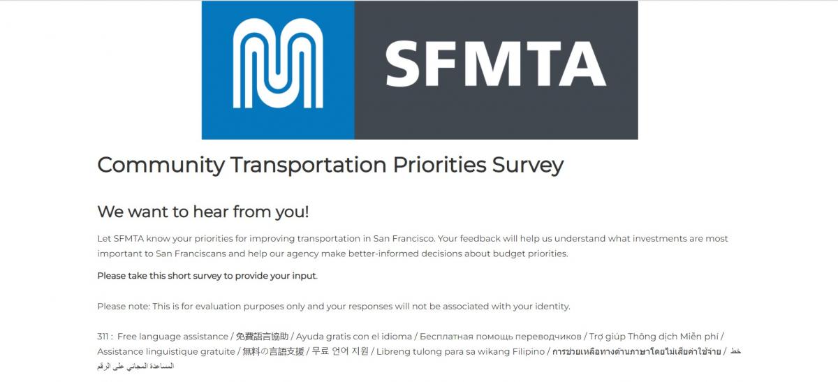
Online Survey: We invite you to give us feedback about your transportation priorities by filling out this short survey. It’s available in English, Spanish, Chinese and Filipino. We’ve included an open-ended question so you can let us know if there’s a specific transportation priority you want to let us know about. 

Community Transportation Priorities Survey image

Online Listening Sessions: We’re hosting two listening sessions that will include a short budget presentation and time to hear your questions and suggestions. You can request simultaneous interpretation in any language for our budget listening sessions by calling 415.646.2109 at least 48 hours prior.  

Online Town Hall: At our online Town Hall meeting, we’ll share the feedback we heard from the survey and online listening sessions. 

March 10, 2022, 6:00 p.m. - 7:00 p.m.  
Get login information at SFMTA Budget Planning - Fiscal Years 2023 & 2024 

After gathering feedback from the public, our directors and our staff, we’ll revise the budget and present it for additional review at two SFMTA Board of Directors meetings: 

SFMTA Board of Directors Budget Meetings:  

  • March 15, 2022, 1:00 p.m. 

  • April 5, 2022, 1:00 p.m. 

Budget Background 

If you’ve been tuning in to our Board of Directors meetings during the two years, you’ll know that the SFMTA’s revenue was severely reduced by the COVID-19 pandemic. COVID devastated our transit fare and parking revenues, which are two of our three biggest revenue sources. Even now, our transit revenues are about 75% lower than pre-pandemic levels and parking revenues are 20% lower.  

The recovery of our transit fare and parking revenue depends on the pace of San Francisco’s economic recovery, which is still uncertain. Data from the Controller’s Office shows that the city’s economy and downtown are recovering more slowly than comparable metropolitan areas. 

This compounded the financial problems our agency already had. Over the last 20 years, the demands on San Francisco’s transportation system have grown and revenues haven’t kept up. Our agency has what’s called a “structural deficit” -- the amount of money it takes to operate our system costs more than the revenues we take in. 

We got through the last two years because we fought for and won San Francisco’s fair share of federal pandemic relief funding and then we were prudent about using that funding to restore service.  

Recently, our short-term budget outlook has somewhat improved because some of the external revenue sources we rely on did better than expected. We’re receiving more money than we thought we would from the San Francisco General Fund and need to spend less on our pension costs. Still, according to the Controller’s Office, the SFMTA will face a structural deficit of approximately $20 - $50 million every year beginning in FY 2024-25.  

This background informs the FY 2023 to FY 2024 base budget that we’re asking for feedback on. It tries to balance the need for us to restore and expand services with the need to maintain the agency’s long-term economic stability. 

Click below to view the budget website in:  

Español - 繁體中文Filipino    


Published March 01, 2022 at 11:03AM
https://ift.tt/BameGSR

The Golden Gate Park Shuttle: Back and Better than Ever!

The Golden Gate Park Shuttle: Back and Better than Ever!
By Eillie Anzilotti

The Golden Gate Park shuttle is shown with the ferris wheel in the background. The sky is bright blue and cloudless.

Over the months of outreach that the SFMTA and our colleagues at the San Francisco Recreation and Park Department conducted for the Golden Gate Park Access & Safety Program, we heard a lot of feedback on the park shuttle. Specifically, that it needed some TLC.  

Now, the Golden Gate Park free shuttle is getting the major overhaul it deserves. This past weekend, Rec & Park and the SFMTA began rolling out some key improvements to the shuttle—starting with expanded service, a longer and more connected route, more stops, and shorter wait times. These upgrades were informed by feedback from the numerous older and senior residents and members of the disability community, and will create a more accessible, reliable, and enjoyable experience of Golden Gate Park and its cultural institutions. 

A map showing improved park shuttle service. Stops include: Haight and Stanyan, which connects to the 7, 33, and 66 Muni lines; McLaren Lodge; Peacock Meadow; Tennis Center/Dahlia Dell, which connects to blue zone parking; Conservatory of Flowers; Cal Academy, which connects to the 44 and has blue zone parking; 10th Ave/DeYoung, which connects to the 5R; the rose garden; the Stow Lake boathouse, which has blue zone parking; and Transverse, which connects to blue zone parking.

Here are some more details on all the improvements:  

  • New weekday service from noon to 6 p.m. with pickup every 20 minutes 

  • Adding a third shuttle to existing weekend service from 9 a.m. to 6 p.m. with pickup every 15 minutes 

  • Connections to the Haight Ashbury neighborhood and its cafes, shops, and bus lines, as well as the park’s renovated Stanyan Street edge.   

  • Shuttle information that is easier to find and use online, including on navigation apps.  

  • New stops, including:  

  • Stow Lake Boathouse and café, with easy access to Strawberry Hill and its lakeside path, waterfall, picnic areas and Chinese Pavilion. 

  • Haight and Stanyan streets near Whole Foods Market with connection to Muni lines 7, 33 and 66.  

  • 10th Avenue/de Young Museum stop a short distance from the 5-Fulton and closer to the museum’s entrance than ever before.  

Before, the shuttle only ran on weekends—and only along JFK drive. Now, we’re taking steps to integrate the shuttle into the rest of our Muni network and transportation system—in addition to all the improvements above, you’ll now see the shuttle appear on all Muni maps. 

More good news: the recent upgrades are just the first step toward improving the Golden Gate Park Shuttle. More stops, new seating, better signage, and bus shelters are on the horizon—and we’re looking forward to welcoming you on the new and improved shuttle! 


Published March 01, 2022 at 09:51AM
https://ift.tt/xAIX86B