Wednesday, 19 August 2020

New Interactive “Shared Spaces” Map and Dashboard Launched

New Interactive “Shared Spaces” Map and Dashboard Launched
By Phillip Pierce

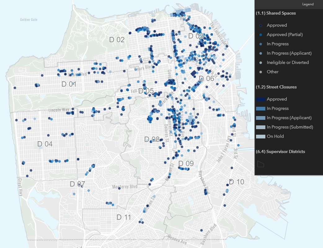
San Francisco’s popular Shared Spaces program, in which the SFMTA is a participating agency, now has an exciting new tool: an interactive map showing the locations and status of all the proposed Shared Spaces locations. The map is designed to make it easier for people to find Shared Spaces, check on permit status or simply track the progress of the program.   

 A static image of the new Shared Space interactive map showing shared spaces around San Francisco

Static image of the new “interactive” map showing Shared Spaces locations and stages in the approval process. Click through for a live view and explore in more detail. 

“We are so excited to see the new Shared Spaces Tracker that lets restaurants, businesses and residents see where the sidewalk and parking lane permit applications are located and details the status of each application,” said Laurie Thomas, Executive Director of the Golden Gate Restaurant Association. “The willingness to share this information publicly is a testament to how well the City has been working with businesses during this unprecedented time.”  

Shared Spaces allows merchants to use sidewalks, full or partial streets, and other nearby public spaces like parks, parking lots and plazas for restaurant pick-up and other neighborhood retail activities allowed under San Francisco’s Public Health Orders. The new program is a multiagency collaboration born out of the city’s Economic Recovery Task Force.   

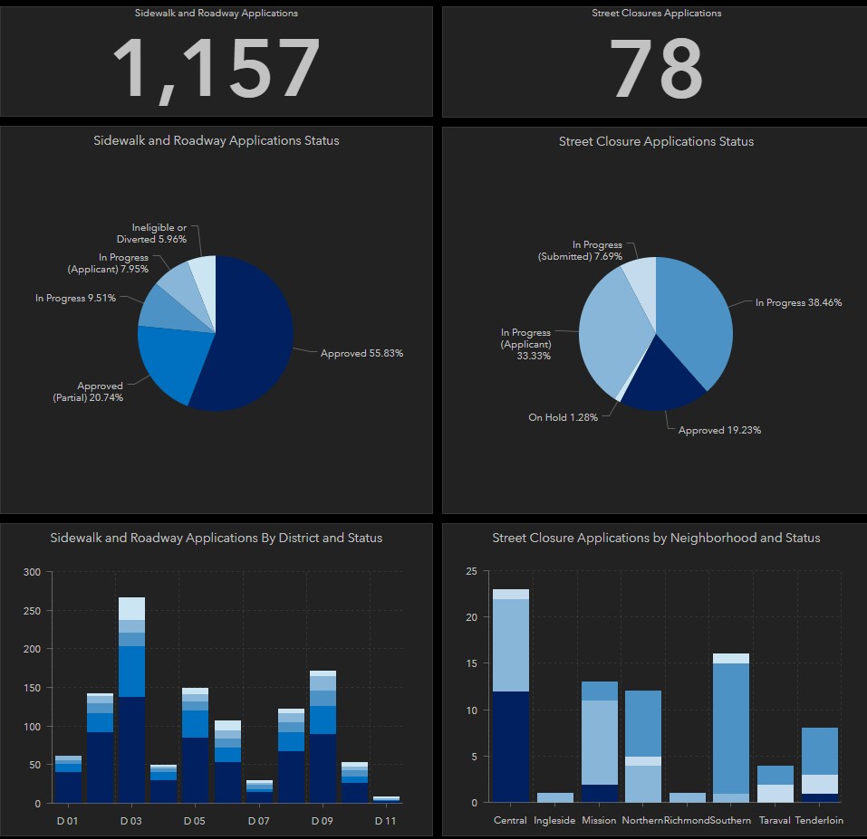
There have been more than a thousand applications for Shared Spaces for uses like outdoor dining in parking spaces or allowing multiple retailers to operate in the open air by repurposing a parking lot. There are important guidelines for the program to ensure accessibility and safety. 

A static picture of the Shared Spaces tracker showing more than a thousand applications

This Shared Space Dashboard is updated daily. Click through for a live view and explore in more detail. 

“The Shared Spaces program is vital to helping businesses like ours survive right now,” said China Live restaurant owners George Chan and Cindy Wong-Chen. “We are grateful for the responsiveness of the city to make this happen in such a short amount of time.”  

Businesses are also applying for temporary full street closures for certain days and hours of the week. The first two successes were Grant Avenue in Chinatown and Valencia Street in the Mission. More recent approvals include Irving Street between 19th and 20th Avenues and Gold Alley in North Beach. Starting later this month, SoMa will have a recurring Shared Space every Sunday on Folsom from 6th to 8th streets. More closures are in the works for the Bayview, Tenderloin, Castro, Excelsior, Marina, Sunset, Richmond and other parts of the city.  

Not every location is a good fit for every type of Shared Space, but the Shared Spaces teams work hard with businesses to find solutions. So far, fewer than 3% of applications were initially ineligible under program guidelines, but most of these were reworked into successful projects.  

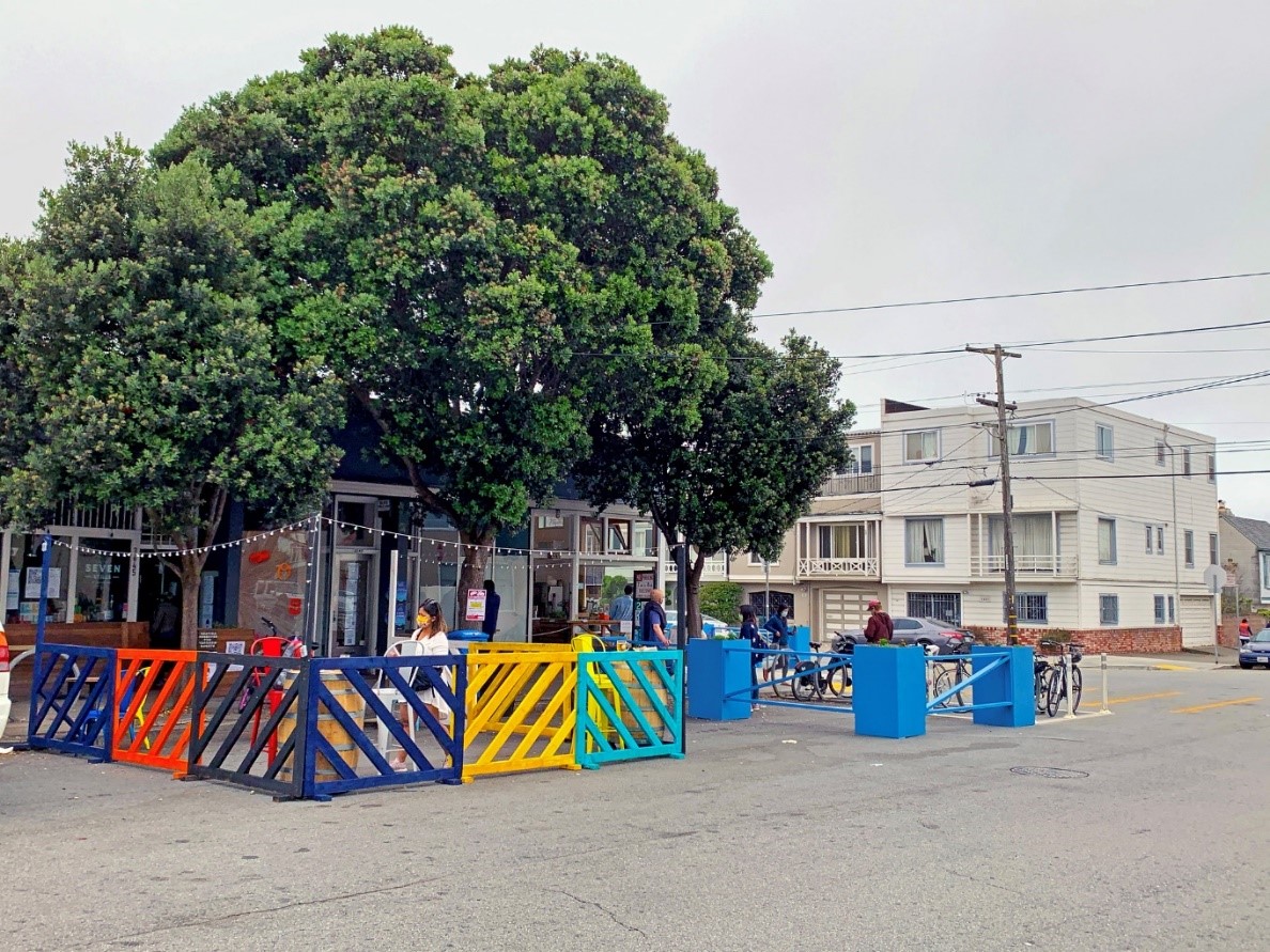
A picture of Seven Still's outdoor dining space with tables and chairs in a former parking space 

Seven Stills – Outer Sunset Taproom created a colorful “Shared Space” at 3545 Lawton. Photo via SF Planning. 

Next Steps: Keep Evolving and More Outreach 

The Shared Spaces program will continue to evolve with new health orders and as other types of business reopen. By looking at the data, we also know that there are more Shared Spaces in some neighborhoods than others. While some of that disparity is related to density and location of restaurants, we also know that not everyone has the resources to take advantage of these programs during this challenging time. In the weeks ahead, we are dedicating more resources to targeted outreach in areas that are not already benefiting from the program.  

For more information on the program or to apply, give feedback, report a problem or view the live tracker, visit sf.gov/SharedSpaces. Questions or media inquiries? Please email SharedSpaces@sfgov.org 


Published August 19, 2020 at 06:48PM
https://ift.tt/2YjPPv4

Tuesday, 18 August 2020

Major Muni Service Expansion August 22

Major Muni Service Expansion August 22
By Mariana Maguire

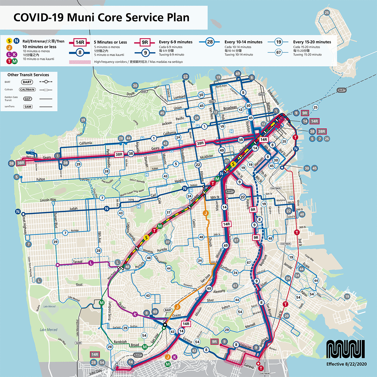
Map: New Muni service map shows bus and rail routes restored August 22 with existing Muni service. This new map also highlights high-frequency corridors.

Map: New Muni service map shows bus and rail routes restored August 22 with existing Muni service. This new map also highlights high-frequency corridors.

On Saturday, August 22, the SFMTA will launch our broadest and most complex service changes since the start of the COVID-19 shelter-in-place order. This includes the restoration or expansion of 11 bus routes, increased frequencies on 13 bus routes and the return of Muni Metro.

These service changes support the city’s essential workers and economic recovery by providing more connections to neighborhood commercial districts. Adding more service on our high ridership lines and upsizing some lines to larger buses will help relieve crowding on those lines.

Service hours will be approximately 5:00 a.m. to 10:00 p.m. daily, unless otherwise noted. Owl network service hours will remain approximately 10:00 p.m. to 5:00 a.m. daily unless otherwise noted.

Below is the complete list of service changes. For more information and details on all our active routes, visit our Core Service Plan page. To learn more about Muni Metro, visit our Rail Recovery page. Please note that some details are subject to change. The information will be updated accordingly.

New temporary transfer points for customers traveling downtown on the J Church at Market and Church and LK Taraval-Ingleside at West Portal. These changes will reduce costly delays in the Muni Metro subway.

New temporary transfer points for customers traveling downtown on the J Church at Market and Church and LK Taraval-Ingleside at West Portal. These changes will reduce costly delays in the Muni Metro subway.

Muni Metro Rail Recovery

J Church

  • New, temporary, surface-only route between Balboa Park and Church at Market
  • New, temporary transfer required to and from downtown at Church Station on frequent trains
  • Daily frequency: Every 6 to 9 minutes.

LK Taraval-Ingleside

  • New, temporary, combined surface-only route between SF Zoo and Balboa Park.
  • New, temporary transfer required to and from downtown at West Portal Station on frequent trains
  • Daily frequency: Every 6 to 9 minutes.

N Judah

  • Full route restored between Ocean Beach (Judah at La Playa) and 4th at King
  • Weekday hours of service: 5:00 a.m. to 10:00 p.m., every 6 to 9 minutes.
  • Weekend hours of service: 8:00 a.m. to 10:00 p.m., every 10 to 14 minutes.

S Shuttle

  • Subway-only line restored between West Portal and Embarcadero
  • Weekday hours of service: 5:00 a.m. to 10:00 p.m., every 6 to 9 minutes.
  • Weekend hours of service: 8:00 a.m. to 10:00 p.m., every 6 to 9 minutes.

TM Third-Oceanview

  • Full T Third and M Oceanview routes, temporarily combined to the new TM Third-Ocean View line between West Portal and Embarcadero
  • Weekday hours of service: 5:00 a.m. to 10:00 p.m., every 10 to 14 minutes.
  • Weekend hours of service: 8:00 a.m. to 10:00 p.m., every 10 to 14 minutes.

Weekend early morning Muni Metro bus substitution (5:00 a.m. to 8:00 a.m.)

To align with BART’s weekend station opening schedule, Muni Metro will not operate in the subway until 8:00 a.m. on weekends. Instead, buses will substitute service during these hours, operating between approximately 5:00 a.m. to 8:00 a.m. on weekends. Please refer to individual route pages for detailed routing and stop locations. Please plan your trip in advance and allow extra time to get to your destination. Some customers may experience additional transfers and longer wait times. Visit our Rail Recovery page to see more details about weekend early morning Metro bus service.

*Be advised, with the restart of Muni Metro rail, Muni Metro buses will no long run along Market Street except as noted.

UPDATE: L Bus Construction Shuttle

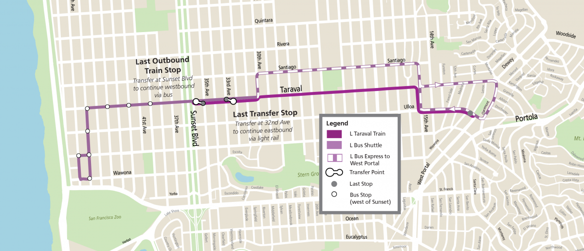
Due to the L Taraval Improvement Project construction, an L Bus Construction Shuttle will substitute the LK Taraval-Ingleside train between the SF Zoo and Sunset Boulevard for approximately seven months, until Spring 2021.

  • Anticipated frequency: Every 10 to 14 minutes.
  • Express Service:
    • To minimize transfers for customers, the L Bus Shuttle will operate as an express bus inbound and outbound between Taraval and 32nd Avenue and Ulloa at Wawona (near the accessible ramps for the LK Taraval-Ingleside at West Portal).
    • This service will not have NextBus predictions; third-party trip planners will also not reference this express service.
  • Local Stops:
    • For service to stops along Taraval heading east toward West Portal, customers must transfer from the L Bus Shuttle at Taraval at 32nd Ave to the LK Taraval-Ingleside train.
    • For service to stops along Taraval heading west toward SF Zoo, customers must transfer from the LK Taraval-Ingleside train to the L Bus Shuttle at Taraval and Sunset.
  • 40-foot buses will serve this temporary route through the construction phase of the L Taraval Improvement Project.

L Construction Bus route

Diagram: Temporary L Taraval Construction Shuttle route

Muni Bus Service Changes

7 Haight-Noriega

  • Extended to full route between Ortega at 48th Avenue and the Salesforce Transit Center
  • 60-foot buses will replace the 40-foot buses, allowing more room for customers to maintain physical distance onboard
  • Connections to Inner Sunset, The Haight and Downtown
  • Daily frequency: Every 10 to 14 minutes

12 Pacific Community Shuttle

  • Temporarily modified route between Jackson and Van Ness to Sansome and Sutter streets to provide connection to Market Street
  • Daily frequency: Every 10 to 14 minutes

14 Mission

  • Line will be served by 60-foot electric trolley coaches instead of motor coaches
  • Daily frequency: Every 6 to 9 minutes

28 19th Avenue

  • Weekend service added for modified route between Daly City BART and California and 7th Avenue
  • Access to transfer points to UCSF, Kaiser and the California Pacific Medical Center
  • Daily frequency: Every 10 to 14 minutes

30 Stockton

  • Route extended to The Presidio between 6:00 a.m. and 8:00 p.m. daily. All other times, the 30 Stockton terminal will be at Divisadero and Chestnut
  • 60-foot electric trolley buses will replace the 40-foot buses, allowing more room for customers to maintain physical distance onboard
  • Connections to Crissy Field, Chinatown, Downtown, and Caltrain
  • Daily frequency: Every 15 to 20 minutes
  • Note: Construction will be ongoing in The Presidio for the first few weeks of August through September, so implementation of the extension will be delayed slightly. Please pay attention to posted signage, follow social media, and visit the website for construction updates.

37 Corbett

  • Temporarily modified route between Twin Peaks and Market and Van Ness streets via Market Street
  • Connections to Castro, Church and Van Ness Muni Metro Stations
  • Daily frequency: Every 15 to 20 minutes
  • Temporary hours of service: 6:00 a.m. to 9:00 p.m. on weekdays, 8:00 a.m. to 9:00 p.m. on weekends

38 Geary

  • Between 6:00 a.m. to 9:00 p.m. daily, buses will alternately terminate at Geary Boulevard and 32nd Avenue or Fort Miley VA Hospital.
  • At all other times, all 38 Geary trips will terminate at 48th Avenue and Point Lobos.
  • Buses terminating at Fort Miley VA Hospital will layover then continue on the inbound route to all existing stop locations.
  • Weekday frequency: Every 6 to 9 minutes.
  • Weekend frequency: Every 10 to 14 minutes.

44 O’Shaughnessy

  • Extended to full route between Hunters Point and California and 6th Avenue
  • Connections to Bayview, Portola, Glen Park and Forest Hill Stations, Golden Gate Park and Inner Richmond
  • Daily frequency: Every 10 to 14 minutes.

45 Union-Stockton

  • Full route restored between Townsend at 4th Street and Lyon at Greenwich
  • Connections to SoMa, Downtown, Chinatown and Union Street
  • Daily frequency: Every 15 to 20 minutes

48 Quintara-24th St

  • Temporarily modified route between 20th at 3rd streets and West Portal Station
  • Connections to West Portal, 24th Street BART, and Potrero Hill/Dogpatch. Simplified route in Noe Valley
  • Daily frequency: Every 10 to 14 minutes

49 Van Ness-Mission

  • 60-foot buses will replace the 40-foot buses, allowing more room for customers to maintain physical distance onboard
  • Daily frequency: Every 6 to 9 minutes

54 Felton

  • Weekend service added and route extended to full route between Daly City BART and Bayview
  • Connections to Bayview, Portola, Excelsior, and Balboa Park and Daly City BART Stations
  • Daily frequency: Approximately every 20 minutes

67 Bernal Heights

  • Full route restored between Ellsworth at Crescent and 24th Street BART Station
  • Daily frequency: Approximately every 20 minutes

Improving Frequency

  • The following lines will have more frequent service to provide more capacity for physical distancing:
    • 8 Bayshore: Daily, every 5 to 6 minutes
    • 9 San Bruno: Daily, every 6 to 9 minutes
    • 9R San Bruno Rapid: Weekday service only, every 6 to 9 minutes
    • 12 Pacific Community Shuttle: Daily, every 10 to 14 minutes
    • 14 Mission: Daily, every 6 to 9 minutes
    • 19 Polk: Daily, every 15 to 20 minutes
    • 22 Fillmore: Daily, every 6 to 9 minutes
    • 24 Divisadero: Daily, every 10 to 14 minutes
    • 25 Treasure Island: Daily, every 15 to 20 minutes
    • 28 19th Ave: Daily, every 10 to 14 minutes
    • 29 Sunset: Weekdays, every 10 to 14 minutes. Weekends, every 20 minutes.
    • 43 Masonic: Weekdays, every 10 to 14 minutes. Weekends, every 20 minutes.
    • 44 O’Shaughnessy: Daily, every 10 to 14 minutes

Focusing Limited Resources

Our August 22 service changes will put us close to maximizing the number of available operators and vehicles out on the street to serve our customers. Due to the need for physical distancing, it now takes three times as many vehicles to move people as before the COVID emergency. At the same time, our budget shortfalls prevent us from hiring more operators and cleaners or purchasing more vehicles. Given these restrictions, these are likely to be the last major service increases tied to the city’s COVID-19 recovery, with exceptions of minor updates.

Learn more about the impact of the pandemic and the financial crisis on the SFMTA, and our focus on customers, equity and efficiency in restoring Muni service.

To provide our customers with the best service we’ve focused on:

  • Temporary changes to reduce costly sources of delay and duplicative service
  • Meeting ridership demands during the pandemic

Customer Reminders

Remember, we still need your help. Help reduce the risk of COVID-19 transmission by:

Use alternate transportation whenever possible – walk, bike or take a taxi – to save a seat on Muni for those who don’t have other options.

If you do need to travel on Muni:

  • Please respect your Muni operator. They are working hard for you and want to stay healthy too.

Face coverings are required on Muni. To avoid getting passed up, cover your nose and mouth with face cover or mask while you are waiting for Muni and on Muni.

  • Board by the back door unless you require assistance.
  • Give yourself extra time. Your trip may now include transfers and a longer walk. Your fare is good for two hours across multiple routes. 

Visit our COVID-19 Developments and Response page for the latest information about Muni routes in service or to explore alternate ways to get around the city. To provide feedback on any Muni service changes please use our Muni Feedback Form.


Published August 18, 2020 at 02:02PM
https://ift.tt/3iWsMP5

Thursday, 13 August 2020

The California Street Safety Project is Complete!

The California Street Safety Project is Complete!
By Erin McMillan

You may have already noticed the fresh paint and new lane configuration on California Street from Arguello Boulevard to Park Presidio. This recently completed ‘road diet’ painted on California Street changed the lane configuration from four lanes to three with a center turn lane to help improve safety along the corridor. 

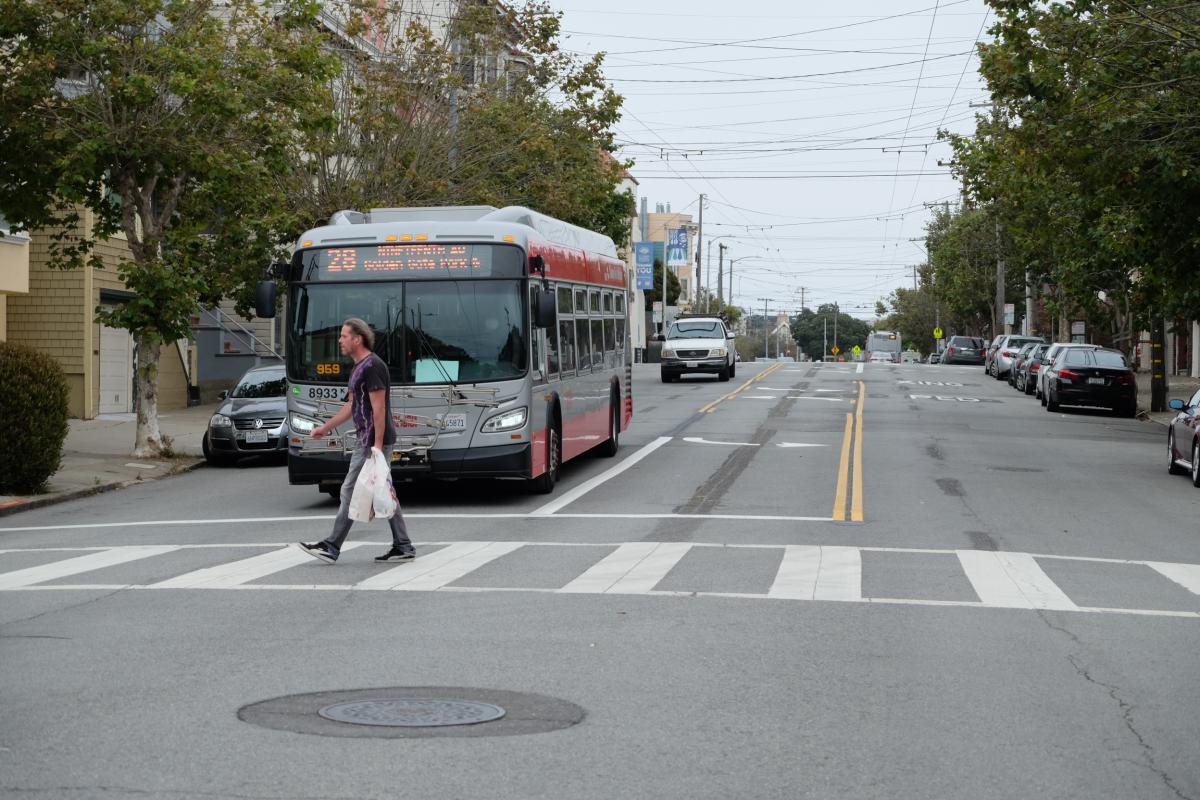
Man walking in crosswalk in front of a bus
California Street and 10th Avenue post-construction

This was the final safety element to be implemented as part of the California Street Safety Project, which began earlier this year with “daylighting” to increase visibility at intersections.  

Why a road diet on California? 

California Street is part of the city’s Vision Zero high-injury network -- the 13% of city streets that account for 75% of severe and fatal collisions. 

This section of California had 73 injury collisions in five years with 7 involving pedestrians. In addition, there have been 35 Muni-involved collisions, many due to narrow lanes. 

  • Road diets reduce speeding and risk of collision by reducing the number of lanes 
  • Wider lanes provide room for safer operation of Muni vehicles 
  • A separate turn lane allows turning traffic to be separate from traveling traffic  
  • Fulton Street: Road diet reduced collisions by over 40%  
  • 25th Avenue: Road diet reduced collisions by 20%   

Earlier this year, several safety elements for pedestrians were installed, including:   

  • Daylighting: Red painted curbs at intersection approaches to improve visibility for all road users 
  • Higher visibility zebra-striped continental crosswalks 
  • Updated pavement markings 

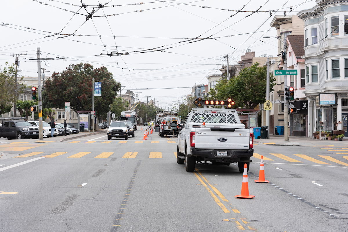
Construction crews working at California and 6th
Construction crews working at California Street and Sixth Avenue pre-construction

Starting this fall summer, we’ll begin the evaluation of the project. The evaluation will include traffic and street-level data, such as tracking changes in collisions, traffic volumes on California and side streets, and driving behavior. In addition to traffic and street-level data collection, we’ll be collecting experiential feedback from neighbors via email. Given the impacts of COVID-19, we’ll also be waiting to collect some post-implementation data until the city’s traffic returns to pre-COVID levels. 

We also received extensive feedback during project outreach in 2019 and will be using that input to shape our evaluation and monitoring of the project. Thank you to everyone who chimed in on this important project and we that will improve the area for years to come. 

To learn more, visit www.SFMTA.com/CaliforniaSafety. Want to give your feedback on any element of the California Street Safety Project? Email us at CaliforniaSafety@SFMTA.com. 


Published August 13, 2020 at 11:31AM
https://ift.tt/3g1lcko

Wednesday, 12 August 2020

Making Accessible Transfers for Muni Metro Beginning August 22

Making Accessible Transfers for Muni Metro Beginning August 22
By Mariana Maguire
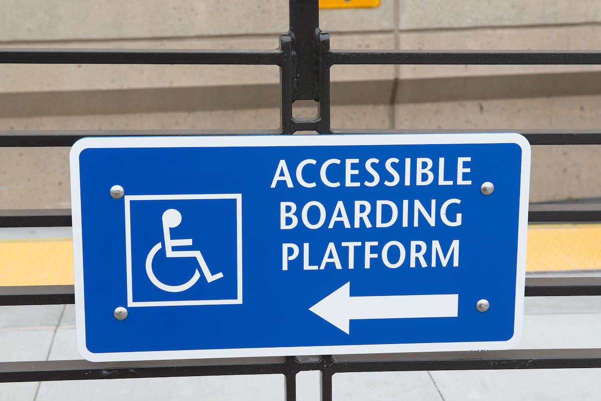
Photo: Accessible Muni Metro boarding platform placard

Photo: Accessible Muni Metro boarding platform placard

In preparation for new temporary LK Taraval-Ingleside and J Church transfers, we are constructing temporary accessible curbside platforms and temporary transfer zones. These changes will support safe and accessible customer movement between Metro lines when Muni Metro returns on August 22.

These new transfers to and from the subway for customers traveling to or from downtown will be required when the L Taraval and K Ingleside are temporarily combined into a new surface-only LK Taraval-Ingleside route between the SF Zoo and Balboa Park. Similarly, the J Church will become a surface-only route that will turn back at Church and Market streets. While we expect these changes to significantly increase the reliability of rail service, these changes require new infrastructure to make transfers accessible.

Many of our customers with disabilities rely on transit. While the temporary changes to Muni Metro will bring significant benefits to the entire system, especially for customers traveling through the subway, these additional transfers may also present new challenges for some customers. Temporary accessible boarding platforms are critical to supporting our customers with mobility devices, people with strollers, and others who may have difficulty boarding using stairs.
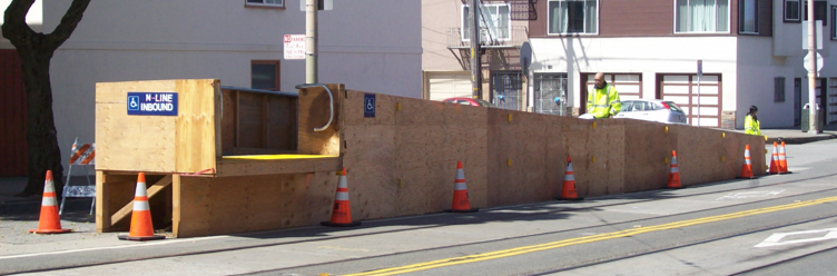
Photo: Example of a temporary accessible boarding ramp

Photo: Example of a temporary accessible boarding ramp

West Portal LK Transfer Project
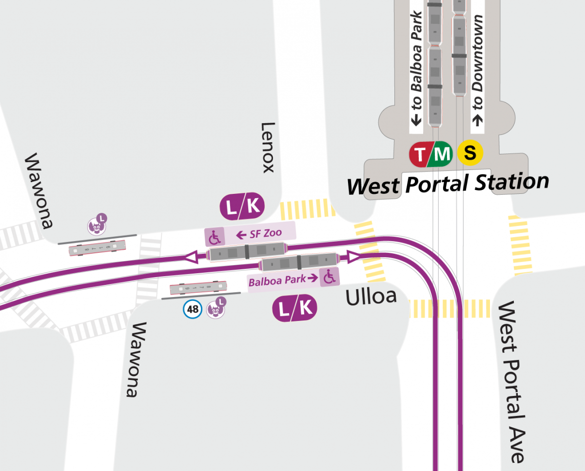
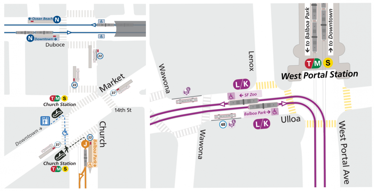
Diagram: New LK Taraval-Ingleside transfer

Diagram: New LK Taraval-Ingleside transfer at West Portal. Note the L Owl and 48 Quintara-24th will share a bus stop near the new train stop.

LK Taraval-Ingleside customers headed downtown will need to transfer at West Portal. The West Portal LK Transfer Project plans to build accessible curbside boarding platforms on Ulloa Street between West Portal Avenue and Wawona Street for the new LK Taraval-Ingleside stops, as well as implement several other street changes near West Portal Station to better accommodate customers transferring to and from West Portal station at these intersections.

LK Taraval-Ingleside trains heading both eastbound toward Balboa Park and westbound toward SF Zoo will stop on Ulloa Street near West Portal Station to let able-bodied customers board or get off. The train will then advance to the new temporary accessible curbside platforms to drop off and pick up customers with mobility devices, strollers, and others who may have difficulty boarding using stairs.

Customers continuing downtown can enter West Portal Station to board the S Shuttle or TM Third-Ocean View. Note that S Shuttle will use the inbound platform for both boarding and alighting.

Click on the animation below to see how this new configuration will work for customers.
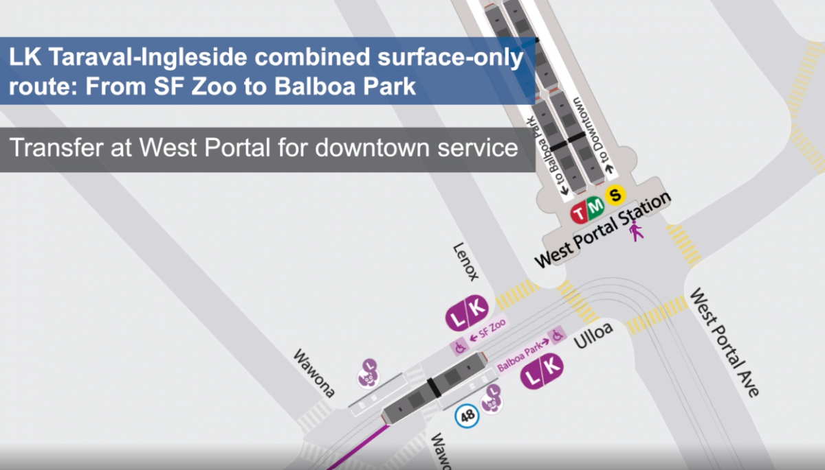
Animation: LK Taraval-Ingleside transfer point at West Portal

Animation: LK Taraval-Ingleside transfer point at West Portal

Another option for customers on the LK Taraval-Ingleside coming from Balboa Park is to transfer to the TM Third-Ocean View using the existing accessible stop at St. Francis Circle and continue downtown on the TM Third-Ocean View line without needing to change trains again at West Portal.

Wayfinding signs will be posted at the new LK stops and at West Portal Station to help customers navigate this change. We will also post Muni Ambassadors in the area for several days to help direct customers.
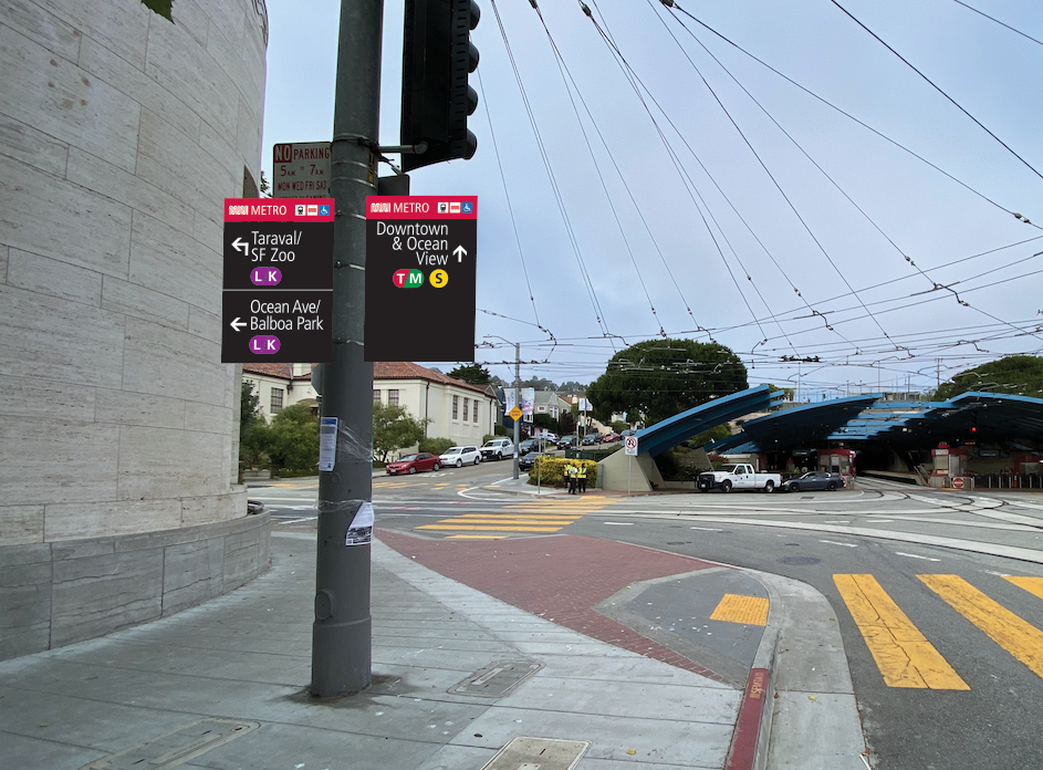
Image: Rendering of new wayfinding signage that will be temporarily installed at West Portal

Image: Artist rendering of new LK Taraval-Ingleside wayfinding signage that will be installed at West Portal


J Church Transfer Improvement Project
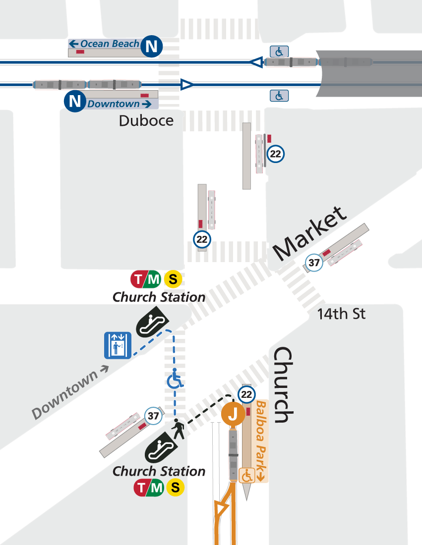
Diagram: New temporary J Church transfer

Diagram: New J Church transfer at Church and Market streets

Starting August 22, the last inbound stop for the J Church will be on Church Street at Market Street, near Church Street Station. J Church customers will need to transfer to Church Street Station for downtown service. These customers can catch the new, subway-only S Shuttles or the new combined TM Third-Oceanview from Church Street Station. Trains will not cross Market street but instead turn back toward Balboa Park Station.

To facilitate the turn-around, we will install a temporary emergency transit zone on Church Street between Market and 15th streets. This allows J Church passengers to use the existing accessible platform to connect with the subway for both inbound and outbound trips. This transit zone limits traffic to ensure a safer boarding process for J Church customers and to limit conflicts with the train turning maneuvers.

For customers heading inbound toward downtown, J Church trains will stop on Church Street at Market Street to let customers with mobility devices, strollers, and others who may have difficulty boarding using stairs board at the existing accessible platform south of Market Street. The train will then pull forward for customers who do not need accessible boarding. This follows the same process as usual at this stop.

Customers continuing downtown who need to use the elevator to access Church Station can cross Church Street heading west and then cross Market Street heading north. The Church Station elevator is located on the northwest corner of Market Street and Church Street. Customers can also access Church Street Station via escalator on either the southwest or northwest side of Market Street.

Click on the animation below to see how this new configuration will work for customers.
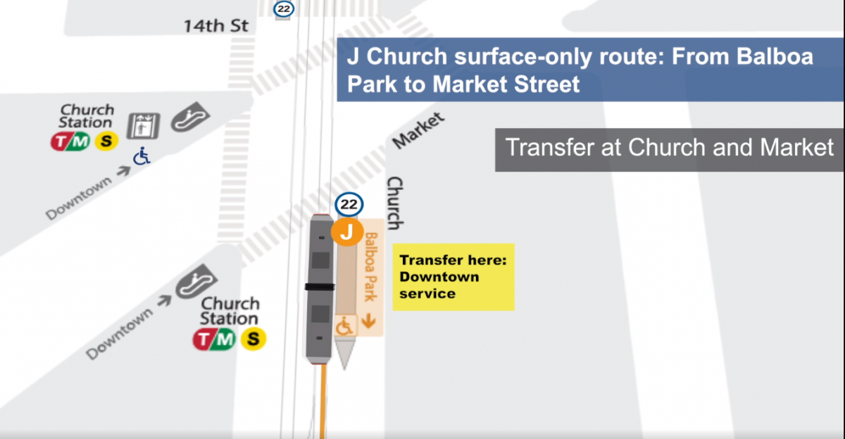
Animation: J Church transfer point at Church and Market streets

Animation: J Church transfer point at Church and Market streets

Just like the new temporary LK Taraval-Ingleside, the temporary J Church will feature wayfinding signage and Ambassadors both at street level and in the subway to guide transferring customers.
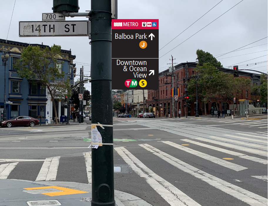
Image: Example of new wayfinding signage that to be installed at Church and Market streets

Image: Example of new wayfinding signage that to be installed at Church and Market streets


Our transfer improvement projects, and service changes teams are conducting robust outreach to community-based organizations, merchants, stakeholders, neighbors and essential businesses and services to inform the public about these important temporary changes. Feedback from these efforts will directly shape the process for evaluating and adjusting the design of these changes. Note that these changes are temporary. Long-term changes will require additional public process.

We want to hear from you and welcome your feedback.


COVID Rider Reminders

Help the city reduce COVID transmission rate by continuing to stay at home except for essential trips. Shop local and support your neighborhood businesses. Always wear a face covering and maintain physical distance.

Use alternate transportation whenever possible – walk, bike, taxi or drive – to save a seat on Muni for those who don’t have other options. Our subsidized Essential Trips Card program is an alternative for seniors and people with disabilities to use taxis instead of Muni if that better meets their needs. Carshares and micromobility options are also available. Visit our COVID-19 Developments and Response page for more information.

If you do need to travel on Muni:

  • Please respect your Muni operator. They are working hard for you.
  • Face coverings are required on Muni. To avoid getting passed up, cover your nose and mouth with face cover or mask.
  • Board by the back door unless you require assistance.
  • Give yourself extra time. Your trip may now include transfers and a longer walk, and your fare is good for two hours across multiple routes. 

Visit our COVID-19 Developments and Response page for the latest information about Muni routes in service or to explore alternate ways to get around the city. To provide feedback on any Muni service changes please use our Muni Feedback Form.


Published August 12, 2020 at 10:58AM
https://ift.tt/2DLQjmN
Tuesday, 11 August 2020

First phase of 16th Street Improvement Project is complete!

First phase of 16th Street Improvement Project is complete!
By Erin McMillan

A new center-running transit lane with boarding island on 16th Street. Soon, the lane will be upgraded with red paint, and a shelter and railings will be installed on the island to complete the project.

A new center-running transit lane with boarding island on 16th Street. Soon, the lane will be upgraded with red paint, and a shelter and railings will be installed on the island to complete the project.

Along 16th Street you may have noticed your ride has gotten a little bit smoother in recent weeks. The first phase of the 16th Street Improvement Project from Potrero to 3rd Street is nearly complete. This means new signalized intersections, new transit islands and transit bulbs for safer and more efficient bus boarding, new pedestrian bulbs to reduce the crossing distance, new ADA ramps at each intersection, new street lights to illuminate the streets, 50 new native trees along 16th street, curb-to curb paving, and new sewer and water pipes. The completion of this phase means a safer and overall more pleasant experience for the community, bus riders, and pedestrians. All completed in less than 18 months. This project made community-informed improvements to address the needs of current and future residents and is part of Muni Forward, an initiative to create a safe, reliable and comfortable experience on and off transit.

Completion of construction of this phase also means that we are one step closer to rerouting 22 Fillmore to serve Mission Bay, traveling east on 16th Street to 3rd Street to utilize the full transit lane and serve Mission Bay medical centers, retail and residences. The timeline for the move is planned for this fall.

The 22 Fillmore typically serves 18,000 daily riders, traveling at less than four miles per hour on parts of 16th Street. In an effort to improve transit reliability and travel times by nearly 25% while addressing safety and accessibility, the 16th Street Improvement Project installed new transit amenities such as new transit islands and transit bulbs that support faster and safer boarding. New traffic signals were installed at Utah, San Bruno, Wisconsin, Connecticut and Missouri streets, in addition to three new traffic signals on 17th Street, that help improve traffic flow and also make it safer for people to cross 16th Street. Soon the transit lane will be painted red and bus shelters will be installed at the new transit boarding islands prior to the 22 Fillmore serving those stops this fall. In addition, completed work includes installation of new sewer and water infrastructure updating an outdated system that now better supports those living and working along 16th Street.

Next up: 16th Street from Church Street to Potrero Avenue

In addition to the eastern section of 16th Street, the west side of 16th Street from Church to Potrero will also undergo construction, including upgrading the sewer line and installing transit amenities like transit bulbs to support more reliable 22 Fillmore service in the Mission. The second phase of the project from Church to Potrero will be delivered through a separate construction project and is anticipated to begin work in early 2021.

As the city gradually reopens, we are moving forward with improvements like the 22 Fillmore project to leverage all of our resources for those who rely on Muni.

For additional information, and to sign up for updates for Phase 2 visit SFMTA.com/16thStreet.


Published August 11, 2020 at 01:35PM
https://ift.tt/3fMlnzJ

Wednesday, 5 August 2020

Virtual Public Hearing on the Folsom Quick-Build Project

Virtual Public Hearing on the Folsom Quick-Build Project
By Benjamin Barnett

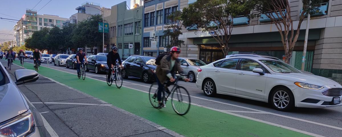
bikers in the bike lane
Existing conditions of the project area that are slated for improvements.

The SFMTA will be holding a Virtual Engineering Public Hearing on the Folsom Quick-Build Project. This project is an effort to improve traffic safety and comfort for all people traveling along Folsom Street between Second and Fifth streets by implementing cost-effective and temporary design treatments that can be installed quickly. At the event you can learn more about the proposed changes, ask questions, or make official public comments.

Virtual Public Hearing Details:  

The interactive, online event can be accessed at any time during the two-week period listed below. Like the SFMTA’s in-person project open houses, when you access the event you will be able to learn more about the project such as the schedule, project background, and other aspects through virtual informational boards. The public will then have an opportunity to see the proposed design, ask questions via email, and leave a public comment about the project. Project staff will respond to questions and comments received and the responses will be posted back to the Virtual Public Hearing web page in a couple of days.

Join us online any time starting 9:30 a.m. Wednesday, August 12 through 11:30 p.m Wednesday, August 26 by visiting SFMTA.com/FolsomQBHearing

Proposed Quick-build Improvements

The Folsom Street Quick-Build project serves as a temporary traffic safety improvement while the longer-term Folsom Howard Streetscape project finishes the detailed design and prepares for construction. The project will implement the following quick-build improvements to improve traffic safety:

  • Upgrade the existing bike lane to a parking-protected bikeway in the eastbound direction to provide a more comfortable and separated space for people riding bikes
  • Daylighting and modifying or adding advanced limit lines at intersections to improve visibility
  • Improve loading conditions for businesses and residents in the area
  • Traffic lane reduction to redistribute roadway space for all road users

bikes on the bike path
Existing conditions of the project area that are slated for improvements.

Folsom-Howard Streetscape Project

Since 2016, the SFMTA has been working to improve traffic safety and livability on Folsom Street, as part of the Folsom-Howard Streetscape Project in support of the city’s commitment to Vision Zero. After several years of community engagement, analysis, and conceptual design development, the project was approved by the SFMTA Board of Supervisors in June 2019. The project is now in the detailed design phase and the project team is working on finalizing civil design details, coordinating utility work for the proposed hardscape changes, and developing construction level documents. This project will implement traffic safety improvements to better facilitate interactions of various modes, reduce the potential for conflicts, and increase comfort in bicycling and walking.

Language Assistance:  

For free interpretation services, please submit your request 48 hours in advance of meeting to 415.646.4270 

Para servicios de interpretación gratuitos, por favor haga su petición 48 horas antes de la reunión a 415.646.4270 

如果需要免費口語翻譯,請於會議之前48小時提出要求 415.646.4270 

Para sa libreng serbisyo sa interpretasyon, kailangan mag-request 48 oras bago ang miting 415.646.4270 


Published August 05, 2020 at 12:27PM
https://ift.tt/2Pu7KKK

Tuesday, 4 August 2020

Customer Service Kiosks Provide New Services

Customer Service Kiosks Provide New Services
By Lulu Feliciano

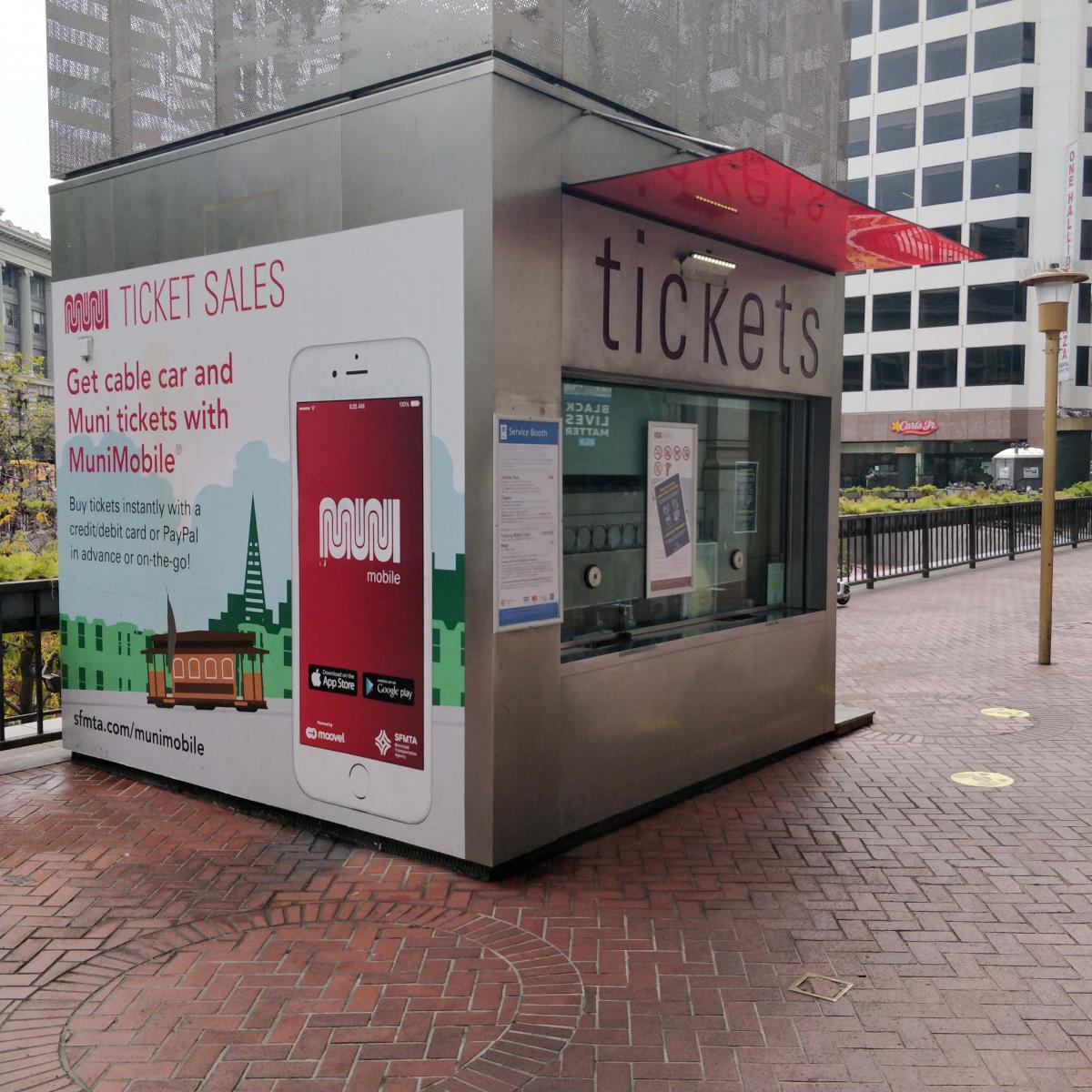
A kiosk at the Powell Street Cable Car

A Customer Service Kiosk at Powell and Market

As the city gradually reopens for business, the SFMTA has moved many of our customer service functions on-line. To support our customers who may need in-person service, we are now using three Muni sales kiosks as alternate locations for services previously only available at the Customer Service Center at 11 South Van Ness.

Doing Business at our Reopened Customer Service Kiosks

The COVID-19 pandemic impacted our city and our agency in countless ways and has required us all to adapt quickly. As an immediate response to the March shelter-in-place public health order and to minimize the risk of exposure for our customers and employees, the SFMTA Customer Service Center located was temporarily closed.

Prior to the closure, the location served approximately 20,000 customers a month for citation payments, low-income fare and citation payment programs, Lifeline monthly pass sales, Clipper card issuance and transactions, and Residential Parking Permits. Over the last few months, we worked to modify program requirements and processes, allowing many functions to be moved online.

Our three currently open sales kiosks are located at Bay & Taylor streets, Powell & Market streets and Presidio Avenue & Geary Boulevard. They operate from 8:00 a.m. to 8:00 p.m., seven days a week except on holidays and during posted breaks.

Services provided at the kiosks:

  • Parking & Transit Citation Payments
  • Clipper sales/Youth & Senior Cards (not available at Bay & Taylor Streets)
  • Lifeline Monthly Pass sales

Redirecting services such as Lifeline sales and citation payments will eventually allow the Customer Service Center to reopen under a much more limited capacity by redirecting up to 75% of the prior transactions on-line and to these alternate sites to minimize risk for both customers and staff.

Citations and Late Penalties

In response to the health orders and shelter in place, we also temporarily suspended enforcing late penalties on citations. However, the SFMTA’s dire financial situation caused by the pandemic requires us to resume generating revenue. Revenue from citations and late penalties allows us to continue to provide critical transportation services for essential works and transit-dependent customers.

We are now resuming the enforcement of late penalties on parking and transit citations as follows: 

  • Deadline for submitting citation protests, payment and community service plans: September 1, 2020 
  • For parking or transit citations issued before July 21, 2020, full payment of outstanding amounts due, or protests, must be received on, or before, August 31, 2020.
  • Standard timelines apply to all citations issued after July 21, 2020.

Customers are encouraged to pay citations online at www.SFMTA.com/paycitation or visit an SFMTA service booth to pay citations. The SFMTA Customer Service Center remains closed.


Published August 04, 2020 at 05:15PM
https://ift.tt/30u08ye